You are here: Home > Network List > XA95 - Missouri to Massachusetts Transect Stations List
> Station MM05 Gleason, Pennsylvania > Earthquake Result Viewer
MM05 Gleason, Pennsylvania - Earthquake Result Viewer
| Earthquake location: |
Kuril Islands |
| Earthquake latitude/longitude: |
45.3/149.9 |
| Earthquake time(UTC): |
1996/02/07 (038) 21:36:45 GMT |
| Earthquake Depth: |
33 km |
| Earthquake Magnitude: |
6.3 MB, 7.0 MS, 7.2 UNKNOWN, 7.1 MW |
| Earthquake Catalog/Contributor: |
WHDF/NEIC |
|
| Network: |
XA Missouri to Massachusetts Transect |
| Station: |
MM05 Gleason, Pennsylvania |
| Lat/Lon: |
41.65 N/76.92 W |
| Elevation: |
701 m |
|
| Distance: |
83.8 deg |
| Az: |
33.35 deg |
| Baz: |
328.831 deg |
| Ray Param: |
0.04586664 |
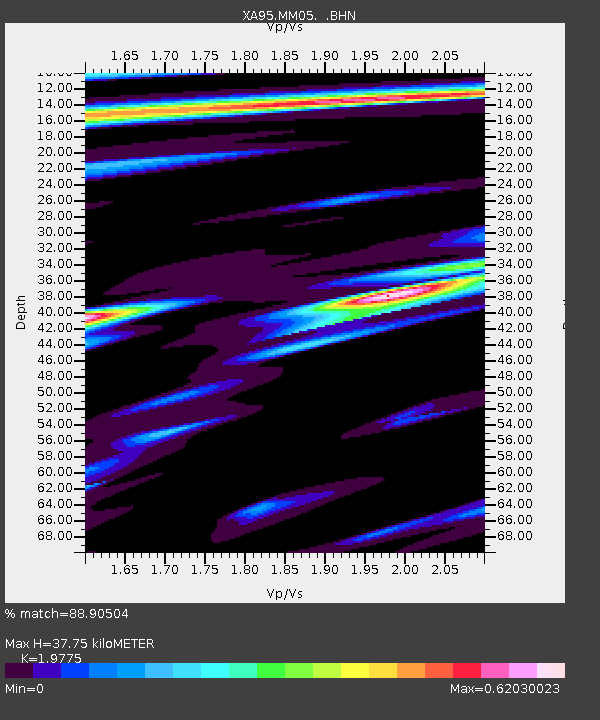
| Estimated Moho Depth: |
37.75 km |
| Estimated Crust Vp/Vs: |
1.98 |
| Assumed Crust Vp: |
6.121 km/s |
| Estimated Crust Vs: |
3.095 km/s |
| Estimated Crust Poisson's Ratio: |
0.33 |
|
| Radial Match: |
88.90504 % |
| Radial Bump: |
400 |
| Transverse Match: |
84.163666 % |
| Transverse Bump: |
400 |
| SOD ConfigId: |
6273 |
| Insert Time: |
2010-02-26 17:46:15.540 +0000 |
| GWidth: |
2.5 |
| Max Bumps: |
400 |
| Tol: |
0.001 |
|
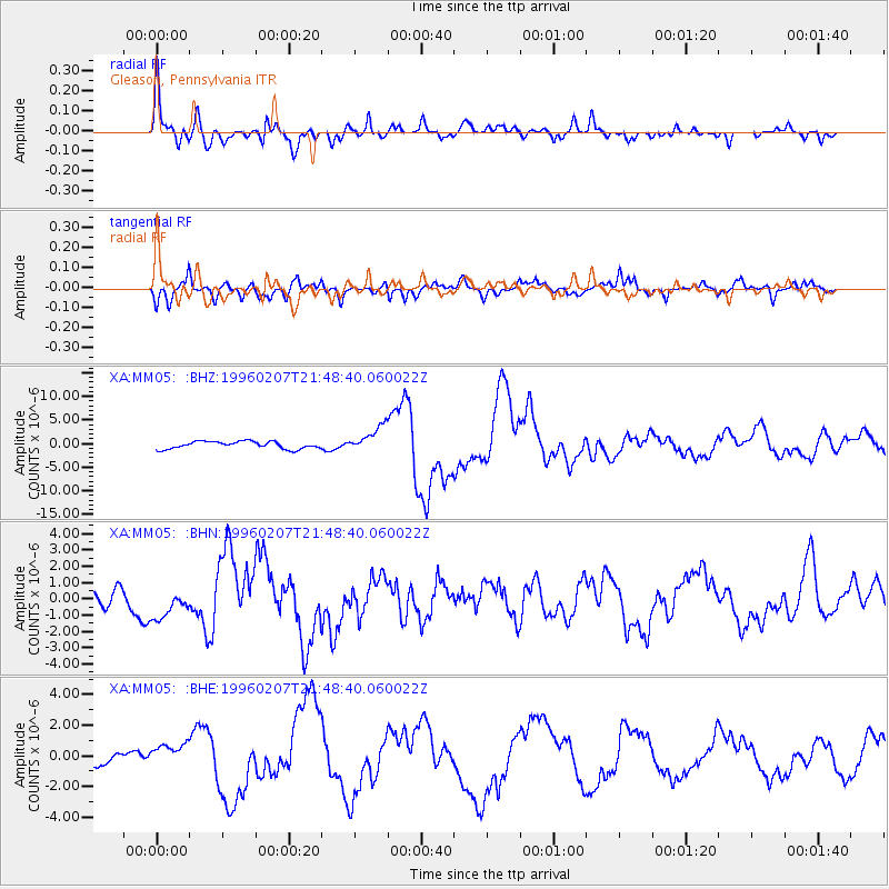
Signal To Noise
| Channel | StoN | STA | LTA |
| XA:MM05: :BHN:19960207T21:48:40.060022Z | 1.3061355 | 9.10107E-7 | 6.9679373E-7 |
| XA:MM05: :BHE:19960207T21:48:40.060022Z | 1.1482127 | 7.5393854E-7 | 6.5661925E-7 |
| XA:MM05: :BHZ:19960207T21:48:40.060022Z | 3.5182226 | 2.7451993E-6 | 7.802802E-7 |
| Arrivals |
| Ps | 6.2 SECOND |
| PpPs | 18 SECOND |
| PsPs/PpSs | 24 SECOND |


