You are here: Home > Network List > XA95 - Missouri to Massachusetts Transect Stations List
> Station MM05 Gleason, Pennsylvania > Earthquake Result Viewer
MM05 Gleason, Pennsylvania - Earthquake Result Viewer
| Earthquake location: |
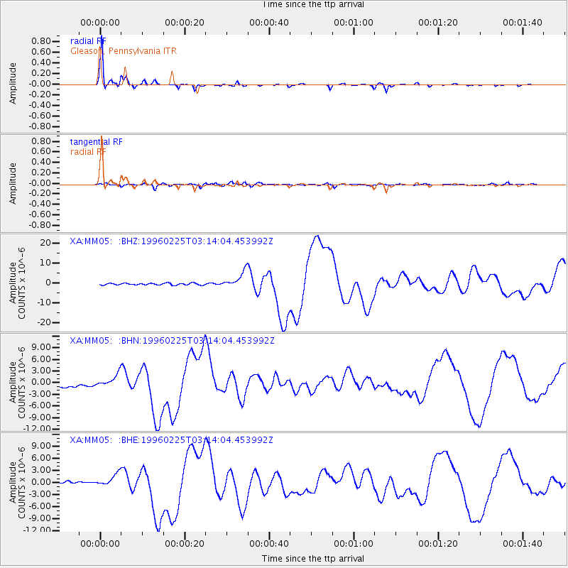
Oaxaca, Mexico |
| Earthquake latitude/longitude: |
16.2/-98.0 |
| Earthquake time(UTC): |
1996/02/25 (056) 03:08:18 GMT |
| Earthquake Depth: |
33 km |
| Earthquake Magnitude: |
5.9 MB, 6.9 MS, 7.1 UNKNOWN, 7.0 MW |
| Earthquake Catalog/Contributor: |
WHDF/NEIC |
|
| Network: |
XA Missouri to Massachusetts Transect |
| Station: |
MM05 Gleason, Pennsylvania |
| Lat/Lon: |
41.65 N/76.92 W |
| Elevation: |
701 m |
|
| Distance: |
31.2 deg |
| Az: |
31.32 deg |
| Baz: |
221.793 deg |
| Ray Param: |
0.0791085 |
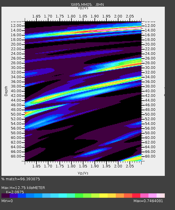
| Estimated Moho Depth: |
12.75 km |
| Estimated Crust Vp/Vs: |
2.10 |
| Assumed Crust Vp: |
6.121 km/s |
| Estimated Crust Vs: |
2.918 km/s |
| Estimated Crust Poisson's Ratio: |
0.35 |
|
| Radial Match: |
96.393875 % |
| Radial Bump: |
242 |
| Transverse Match: |
79.20408 % |
| Transverse Bump: |
400 |
| SOD ConfigId: |
6273 |
| Insert Time: |
2010-02-26 17:46:17.662 +0000 |
| GWidth: |
2.5 |
| Max Bumps: |
400 |
| Tol: |
0.001 |
|
Signal To Noise
| Channel | StoN | STA | LTA |
| XA:MM05: :BHN:19960225T03:14:04.453992Z | 1.3258468 | 1.5528499E-6 | 1.1712136E-6 |
| XA:MM05: :BHE:19960225T03:14:04.453992Z | 4.4764805 | 1.6686259E-6 | 3.72754E-7 |
| XA:MM05: :BHZ:19960225T03:14:04.453992Z | 9.557512 | 4.2296515E-6 | 4.425473E-7 |
| Arrivals |
| Ps | 2.4 SECOND |
| PpPs | 6.1 SECOND |
| PsPs/PpSs | 8.5 SECOND |


