You are here: Home > Network List > XA95 - Missouri to Massachusetts Transect Stations List
> Station MM05 Gleason, Pennsylvania > Earthquake Result Viewer
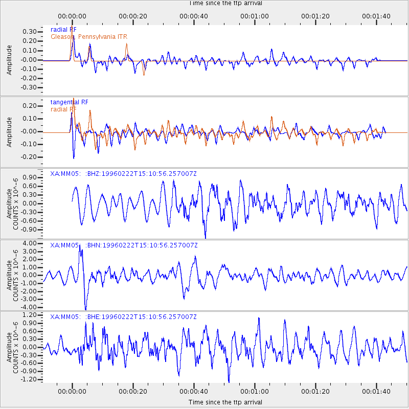
MM05 Gleason, Pennsylvania - Earthquake Result Viewer
*The percent match for this event was below the threshold and hence no stack was calculated.
| Earthquake location: |
Kuril Islands |
| Earthquake latitude/longitude: |
45.2/148.6 |
| Earthquake time(UTC): |
1996/02/22 (053) 14:59:09 GMT |
| Earthquake Depth: |
133 km |
| Earthquake Magnitude: |
6.2 MB, 6.3 UNKNOWN, 6.3 MW |
| Earthquake Catalog/Contributor: |
WHDF/NEIC |
|
| Network: |
XA Missouri to Massachusetts Transect |
| Station: |
MM05 Gleason, Pennsylvania |
| Lat/Lon: |
41.65 N/76.92 W |
| Elevation: |
701 m |
|
| Distance: |
84.4 deg |
| Az: |
32.469 deg |
| Baz: |
329.575 deg |
| Ray Param: |
$rayparam |
*The percent match for this event was below the threshold and hence was not used in the summary stack. |
|
| Radial Match: |
76.17363 % |
| Radial Bump: |
400 |
| Transverse Match: |
62.515873 % |
| Transverse Bump: |
400 |
| SOD ConfigId: |
4480 |
| Insert Time: |
2010-02-26 17:46:21.116 +0000 |
| GWidth: |
2.5 |
| Max Bumps: |
400 |
| Tol: |
0.001 |
|
Signal To Noise
| Channel | StoN | STA | LTA |
| XA:MM05: :BHN:19960222T15:10:56.257007Z | 5.8882513 | 2.1242627E-6 | 3.6076295E-7 |
| XA:MM05: :BHE:19960222T15:10:56.257007Z | 1.4677619 | 3.233764E-7 | 2.2031941E-7 |
| XA:MM05: :BHZ:19960222T15:10:56.257007Z | 1.5010475 | 5.153926E-7 | 3.433553E-7 |
| Arrivals |
| Ps | |
| PpPs | |
| PsPs/PpSs | |


