You are here: Home > Network List > XA95 - Missouri to Massachusetts Transect Stations List
> Station MM05 Gleason, Pennsylvania > Earthquake Result Viewer
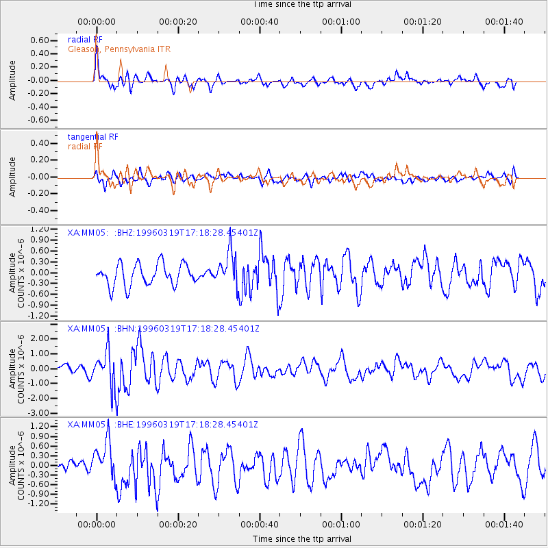
MM05 Gleason, Pennsylvania - Earthquake Result Viewer
*The percent match for this event was below the threshold and hence no stack was calculated.
| Earthquake location: |
Near Coast Of Oaxaca, Mexico |
| Earthquake latitude/longitude: |
15.9/-97.3 |
| Earthquake time(UTC): |
1996/03/19 (079) 17:12:43 GMT |
| Earthquake Depth: |
33 km |
| Earthquake Magnitude: |
5.8 MB, 5.2 MS |
| Earthquake Catalog/Contributor: |
WHDF/NEIC |
|
| Network: |
XA Missouri to Massachusetts Transect |
| Station: |
MM05 Gleason, Pennsylvania |
| Lat/Lon: |
41.65 N/76.92 W |
| Elevation: |
701 m |
|
| Distance: |
31.2 deg |
| Az: |
30.305 deg |
| Baz: |
220.396 deg |
| Ray Param: |
$rayparam |
*The percent match for this event was below the threshold and hence was not used in the summary stack. |
|
| Radial Match: |
73.911316 % |
| Radial Bump: |
400 |
| Transverse Match: |
57.67785 % |
| Transverse Bump: |
400 |
| SOD ConfigId: |
4480 |
| Insert Time: |
2010-02-26 17:46:22.849 +0000 |
| GWidth: |
2.5 |
| Max Bumps: |
400 |
| Tol: |
0.001 |
|
Signal To Noise
| Channel | StoN | STA | LTA |
| XA:MM05: :BHN:19960319T17:18:28.45401Z | 4.1306214 | 1.2768976E-6 | 3.091297E-7 |
| XA:MM05: :BHE:19960319T17:18:28.45401Z | 2.2611501 | 6.149015E-7 | 2.7194193E-7 |
| XA:MM05: :BHZ:19960319T17:18:28.45401Z | 1.6564186 | 5.003686E-7 | 3.020786E-7 |
| Arrivals |
| Ps | |
| PpPs | |
| PsPs/PpSs | |


