You are here: Home > Network List > XA95 - Missouri to Massachusetts Transect Stations List
> Station MM05 Gleason, Pennsylvania > Earthquake Result Viewer
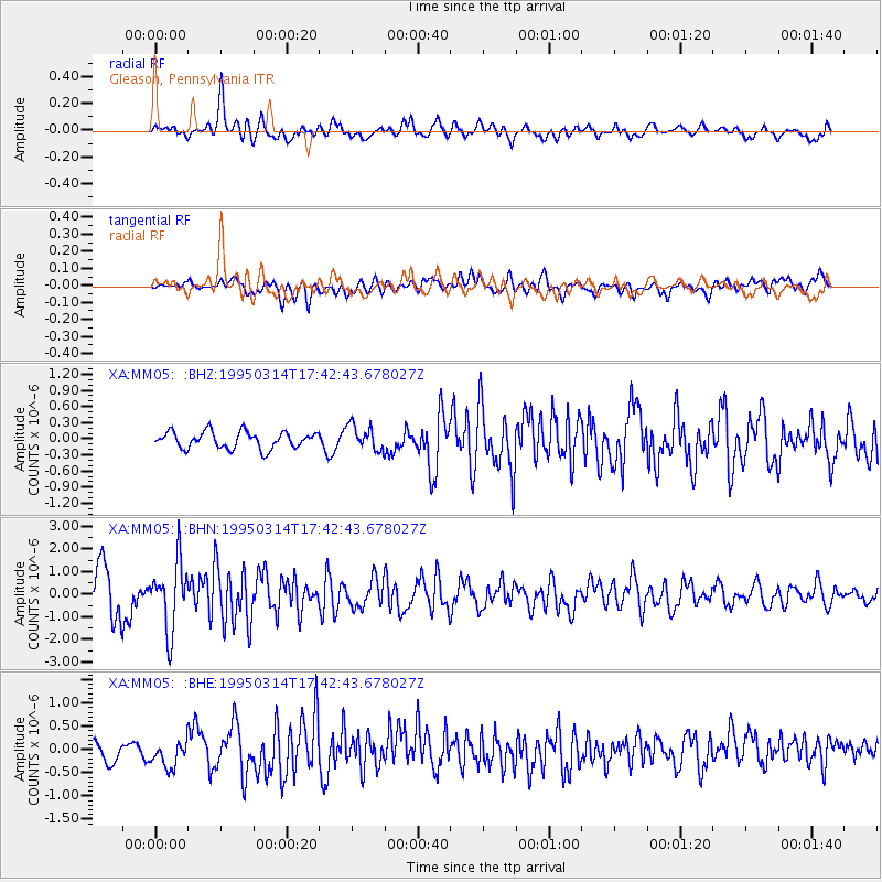
MM05 Gleason, Pennsylvania - Earthquake Result Viewer
*The percent match for this event was below the threshold and hence no stack was calculated.
| Earthquake location: |
Alaska Peninsula |
| Earthquake latitude/longitude: |
54.8/-161.3 |
| Earthquake time(UTC): |
1995/03/14 (073) 17:33:50 GMT |
| Earthquake Depth: |
33 km |
| Earthquake Magnitude: |
6.1 MB, 5.9 MS, 6.2 UNKNOWN, 5.5 ML |
| Earthquake Catalog/Contributor: |
WHDF/NEIC |
|
| Network: |
XA Missouri to Massachusetts Transect |
| Station: |
MM05 Gleason, Pennsylvania |
| Lat/Lon: |
41.65 N/76.92 W |
| Elevation: |
701 m |
|
| Distance: |
54.4 deg |
| Az: |
66.547 deg |
| Baz: |
314.851 deg |
| Ray Param: |
$rayparam |
*The percent match for this event was below the threshold and hence was not used in the summary stack. |
|
| Radial Match: |
80.68735 % |
| Radial Bump: |
400 |
| Transverse Match: |
65.97259 % |
| Transverse Bump: |
400 |
| SOD ConfigId: |
4480 |
| Insert Time: |
2010-02-26 17:46:25.597 +0000 |
| GWidth: |
2.5 |
| Max Bumps: |
400 |
| Tol: |
0.001 |
|
Signal To Noise
| Channel | StoN | STA | LTA |
| XA:MM05: :BHN:19950314T17:42:43.678027Z | 2.5278559 | 1.4866667E-6 | 5.881138E-7 |
| XA:MM05: :BHE:19950314T17:42:43.678027Z | 1.3980985 | 2.9099257E-7 | 2.0813454E-7 |
| XA:MM05: :BHZ:19950314T17:42:43.678027Z | 1.4988345 | 2.3270391E-7 | 1.5525657E-7 |
| Arrivals |
| Ps | |
| PpPs | |
| PsPs/PpSs | |


