You are here: Home > Network List > US - United States National Seismic Network Stations List
> Station HAWA Hanford, Washington, USA > Earthquake Result Viewer
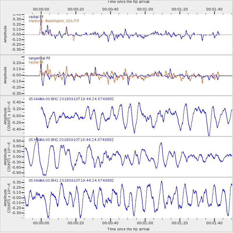
HAWA Hanford, Washington, USA - Earthquake Result Viewer
*The percent match for this event was below the threshold and hence no stack was calculated.
| Earthquake location: |
Southeast Of Loyalty Islands |
| Earthquake latitude/longitude: |
-22.1/170.0 |
| Earthquake time(UTC): |
2018/09/10 (253) 19:31:42 GMT |
| Earthquake Depth: |
10 km |
| Earthquake Magnitude: |
6.6 Mi |
| Earthquake Catalog/Contributor: |
NEIC PDE/at |
|
| Network: |
US United States National Seismic Network |
| Station: |
HAWA Hanford, Washington, USA |
| Lat/Lon: |
46.39 N/119.53 W |
| Elevation: |
364 m |
|
| Distance: |
93.2 deg |
| Az: |
40.792 deg |
| Baz: |
241.09 deg |
| Ray Param: |
$rayparam |
*The percent match for this event was below the threshold and hence was not used in the summary stack. |
|
| Radial Match: |
72.96687 % |
| Radial Bump: |
400 |
| Transverse Match: |
67.95896 % |
| Transverse Bump: |
400 |
| SOD ConfigId: |
2825771 |
| Insert Time: |
2018-09-24 19:46:36.268 +0000 |
| GWidth: |
2.5 |
| Max Bumps: |
400 |
| Tol: |
0.001 |
|
Signal To Noise
| Channel | StoN | STA | LTA |
| US:HAWA:00:BHZ:20180910T19:44:24.674988Z | 2.2815049 | 6.9978717E-7 | 3.0672174E-7 |
| US:HAWA:00:BH1:20180910T19:44:24.674988Z | 1.8663025 | 1.8074816E-7 | 9.684827E-8 |
| US:HAWA:00:BH2:20180910T19:44:24.674988Z | 1.9922473 | 2.1673279E-7 | 1.0878809E-7 |
| Arrivals |
| Ps | |
| PpPs | |
| PsPs/PpSs | |


