You are here: Home > Network List > US - United States National Seismic Network Stations List
> Station MSO Missoula, Montana, USA > Earthquake Result Viewer
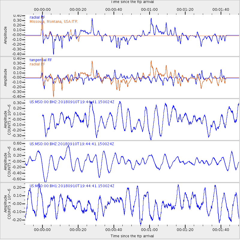
MSO Missoula, Montana, USA - Earthquake Result Viewer
*The percent match for this event was below the threshold and hence no stack was calculated.
| Earthquake location: |
Southeast Of Loyalty Islands |
| Earthquake latitude/longitude: |
-22.1/170.0 |
| Earthquake time(UTC): |
2018/09/10 (253) 19:31:42 GMT |
| Earthquake Depth: |
10 km |
| Earthquake Magnitude: |
6.6 Mi |
| Earthquake Catalog/Contributor: |
NEIC PDE/at |
|
| Network: |
US United States National Seismic Network |
| Station: |
MSO Missoula, Montana, USA |
| Lat/Lon: |
46.83 N/113.94 W |
| Elevation: |
1264 m |
|
| Distance: |
96.8 deg |
| Az: |
42.154 deg |
| Baz: |
245.023 deg |
| Ray Param: |
$rayparam |
*The percent match for this event was below the threshold and hence was not used in the summary stack. |
|
| Radial Match: |
67.37043 % |
| Radial Bump: |
400 |
| Transverse Match: |
58.08685 % |
| Transverse Bump: |
400 |
| SOD ConfigId: |
2825771 |
| Insert Time: |
2018-09-24 19:46:46.660 +0000 |
| GWidth: |
2.5 |
| Max Bumps: |
400 |
| Tol: |
0.001 |
|
Signal To Noise
| Channel | StoN | STA | LTA |
| US:MSO:00:BHZ:20180910T19:44:41.150024Z | 4.740653 | 4.17331E-7 | 8.803238E-8 |
| US:MSO:00:BH1:20180910T19:44:41.150024Z | 0.8350805 | 9.883865E-8 | 1.1835822E-7 |
| US:MSO:00:BH2:20180910T19:44:41.150024Z | 1.3935477 | 1.4279178E-7 | 1.0246638E-7 |
| Arrivals |
| Ps | |
| PpPs | |
| PsPs/PpSs | |


