You are here: Home > Network List > CI - Caltech Regional Seismic Network Stations List
> Station SWS Sam W. Stewart, Westmorland, CA, USA > Earthquake Result Viewer
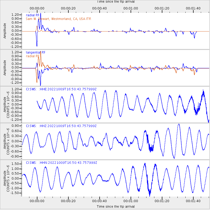
SWS Sam W. Stewart, Westmorland, CA, USA - Earthquake Result Viewer
*The percent match for this event was below the threshold and hence no stack was calculated.
| Earthquake location: |
Central Mid-Atlantic Ridge |
| Earthquake latitude/longitude: |
-1.4/-23.9 |
| Earthquake time(UTC): |
2022/10/09 (282) 16:38:04 GMT |
| Earthquake Depth: |
10 km |
| Earthquake Magnitude: |
6.2 mww |
| Earthquake Catalog/Contributor: |
NEIC PDE/us |
|
| Network: |
CI Caltech Regional Seismic Network |
| Station: |
SWS Sam W. Stewart, Westmorland, CA, USA |
| Lat/Lon: |
32.94 N/115.80 W |
| Elevation: |
140 m |
|
| Distance: |
92.4 deg |
| Az: |
302.739 deg |
| Baz: |
90.131 deg |
| Ray Param: |
$rayparam |
*The percent match for this event was below the threshold and hence was not used in the summary stack. |
|
| Radial Match: |
89.3408 % |
| Radial Bump: |
341 |
| Transverse Match: |
86.3528 % |
| Transverse Bump: |
307 |
| SOD ConfigId: |
28764291 |
| Insert Time: |
2022-10-23 16:44:35.985 +0000 |
| GWidth: |
2.5 |
| Max Bumps: |
400 |
| Tol: |
0.001 |
|
Signal To Noise
| Channel | StoN | STA | LTA |
| CI:SWS: :HHZ:20221009T16:50:43.757999Z | 1.5716764 | 3.4863834E-7 | 2.2182579E-7 |
| CI:SWS: :HHN:20221009T16:50:43.757999Z | 2.159251 | 8.639441E-7 | 4.0011287E-7 |
| CI:SWS: :HHE:20221009T16:50:43.757999Z | 1.5945649 | 6.933033E-7 | 4.3479156E-7 |
| Arrivals |
| Ps | |
| PpPs | |
| PsPs/PpSs | |


