You are here: Home > Network List > XA95 - Missouri to Massachusetts Transect Stations List
> Station MM05 Gleason, Pennsylvania > Earthquake Result Viewer
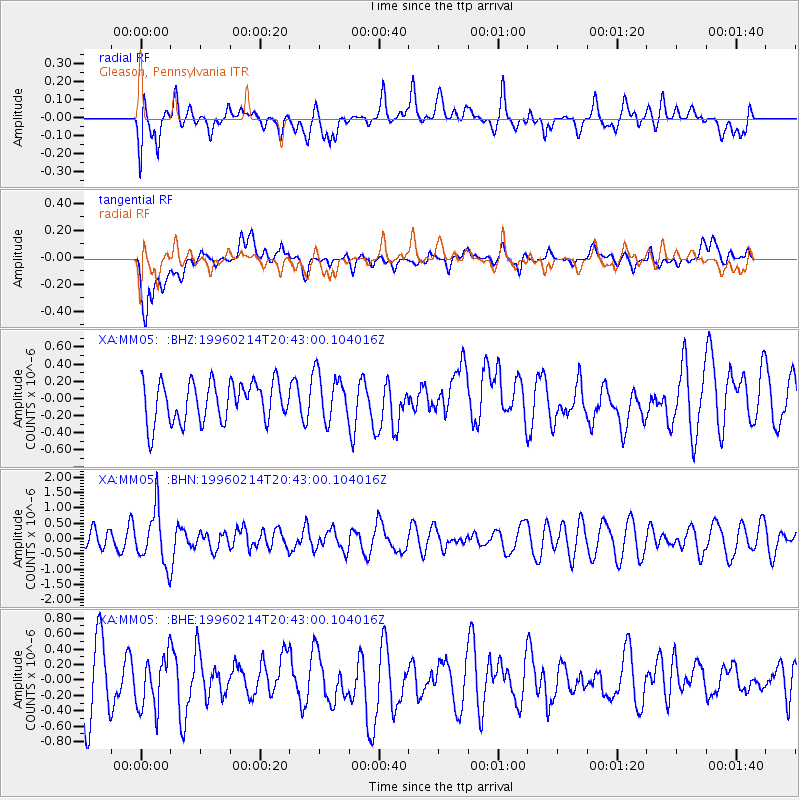
MM05 Gleason, Pennsylvania - Earthquake Result Viewer
*The percent match for this event was below the threshold and hence no stack was calculated.
| Earthquake location: |
Kuril Islands |
| Earthquake latitude/longitude: |
45.4/150.4 |
| Earthquake time(UTC): |
1996/02/14 (045) 20:31:06 GMT |
| Earthquake Depth: |
33 km |
| Earthquake Magnitude: |
5.9 MB, 5.2 MS, 5.8 UNKNOWN, 5.8 MW |
| Earthquake Catalog/Contributor: |
WHDF/NEIC |
|
| Network: |
XA Missouri to Massachusetts Transect |
| Station: |
MM05 Gleason, Pennsylvania |
| Lat/Lon: |
41.65 N/76.92 W |
| Elevation: |
701 m |
|
| Distance: |
83.6 deg |
| Az: |
33.644 deg |
| Baz: |
328.6 deg |
| Ray Param: |
$rayparam |
*The percent match for this event was below the threshold and hence was not used in the summary stack. |
|
| Radial Match: |
53.4336 % |
| Radial Bump: |
400 |
| Transverse Match: |
54.467587 % |
| Transverse Bump: |
400 |
| SOD ConfigId: |
4480 |
| Insert Time: |
2010-02-26 17:46:40.978 +0000 |
| GWidth: |
2.5 |
| Max Bumps: |
400 |
| Tol: |
0.001 |
|
Signal To Noise
| Channel | StoN | STA | LTA |
| XA:MM05: :BHN:19960214T20:43:00.104016Z | 1.7636505 | 8.863109E-7 | 5.025434E-7 |
| XA:MM05: :BHE:19960214T20:43:00.104016Z | 1.0065156 | 3.3998265E-7 | 3.377818E-7 |
| XA:MM05: :BHZ:19960214T20:43:00.104016Z | 1.1721445 | 2.7477407E-7 | 2.3441996E-7 |
| Arrivals |
| Ps | |
| PpPs | |
| PsPs/PpSs | |


