You are here: Home > Network List > XA95 - Missouri to Massachusetts Transect Stations List
> Station MM06 Emporium, Pennsylvania > Earthquake Result Viewer
MM06 Emporium, Pennsylvania - Earthquake Result Viewer

| Earthquake location: |
Alaska Peninsula |
| Earthquake latitude/longitude: |
54.8/-161.3 |
| Earthquake time(UTC): |
1995/03/14 (073) 17:33:50 GMT |
| Earthquake Depth: |
33 km |
| Earthquake Magnitude: |
6.1 MB, 5.9 MS, 6.2 UNKNOWN, 5.5 ML |
| Earthquake Catalog/Contributor: |
WHDF/NEIC |
|
| Network: |
XA Missouri to Massachusetts Transect |
| Station: |
MM06 Emporium, Pennsylvania |
| Lat/Lon: |
41.39 N/78.13 W |
| Elevation: |
647 m |
|
| Distance: |
53.9 deg |
| Az: |
67.562 deg |
| Baz: |
314.65 deg |
| Ray Param: |
0.06571034 |
| Estimated Moho Depth: |
48.0 km |
| Estimated Crust Vp/Vs: |
1.72 |
| Assumed Crust Vp: |
6.121 km/s |
| Estimated Crust Vs: |
3.569 km/s |
| Estimated Crust Poisson's Ratio: |
0.24 |
|
| Radial Match: |
87.862724 % |
| Radial Bump: |
400 |
| Transverse Match: |
53.828804 % |
| Transverse Bump: |
400 |
| SOD ConfigId: |
6273 |
| Insert Time: |
2010-02-26 17:46:41.916 +0000 |
| GWidth: |
2.5 |
| Max Bumps: |
400 |
| Tol: |
0.001 |
|
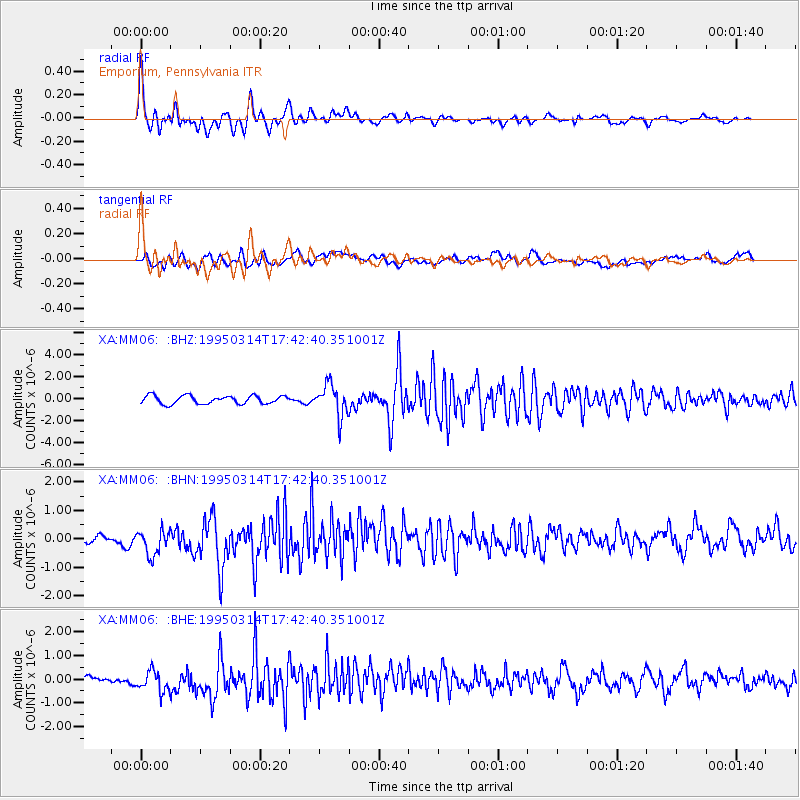
Signal To Noise
| Channel | StoN | STA | LTA |
| XA:MM06: :BHN:19950314T17:42:40.351001Z | 1.7916291 | 4.772066E-7 | 2.6635342E-7 |
| XA:MM06: :BHE:19950314T17:42:40.351001Z | 2.5737839 | 4.5357712E-7 | 1.7622969E-7 |
| XA:MM06: :BHZ:19950314T17:42:40.351001Z | 3.9118884 | 1.4424006E-6 | 3.6872237E-7 |
| Arrivals |
| Ps | 5.9 SECOND |
| PpPs | 20 SECOND |
| PsPs/PpSs | 26 SECOND |


