You are here: Home > Network List > AK - Alaska Regional Network Stations List
> Station F20K Avaraart Lake, AK, USA > Earthquake Result Viewer
F20K Avaraart Lake, AK, USA - Earthquake Result Viewer
| Earthquake location: |
New Ireland Region, P.N.G. |
| Earthquake latitude/longitude: |
-4.8/153.6 |
| Earthquake time(UTC): |
2022/10/13 (286) 22:20:20 GMT |
| Earthquake Depth: |
71 km |
| Earthquake Magnitude: |
6.4 mww |
| Earthquake Catalog/Contributor: |
NEIC PDE/us |
|
| Network: |
AK Alaska Regional Network |
| Station: |
F20K Avaraart Lake, AK, USA |
| Lat/Lon: |
67.05 N/155.73 W |
| Elevation: |
136 m |
|
| Distance: |
80.1 deg |
| Az: |
17.945 deg |
| Baz: |
231.527 deg |
| Ray Param: |
0.04833312 |
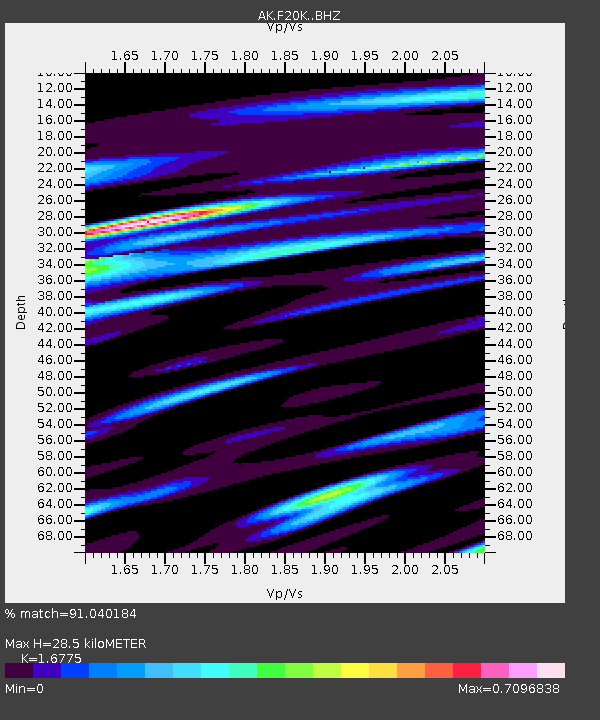
| Estimated Moho Depth: |
28.5 km |
| Estimated Crust Vp/Vs: |
1.68 |
| Assumed Crust Vp: |
6.522 km/s |
| Estimated Crust Vs: |
3.888 km/s |
| Estimated Crust Poisson's Ratio: |
0.22 |
|
| Radial Match: |
91.040184 % |
| Radial Bump: |
400 |
| Transverse Match: |
81.795334 % |
| Transverse Bump: |
400 |
| SOD ConfigId: |
28764291 |
| Insert Time: |
2022-10-27 22:24:19.452 +0000 |
| GWidth: |
2.5 |
| Max Bumps: |
400 |
| Tol: |
0.001 |
|

Signal To Noise
| Channel | StoN | STA | LTA |
| AK:F20K: :BHZ:20221013T22:31:52.200Z | 14.789225 | 1.5439717E-6 | 1.0439843E-7 |
| AK:F20K: :BHN:20221013T22:31:52.200Z | 3.7600143 | 3.560511E-7 | 9.469408E-8 |
| AK:F20K: :BHE:20221013T22:31:52.200Z | 3.7168298 | 4.634804E-7 | 1.2469778E-7 |
| Arrivals |
| Ps | 3.1 SECOND |
| PpPs | 11 SECOND |
| PsPs/PpSs | 14 SECOND |


