You are here: Home > Network List > AU - Australian Seismological Centre Stations List
> Station NWAO Narrogin, Western Australia > Earthquake Result Viewer
NWAO Narrogin, Western Australia - Earthquake Result Viewer
| Earthquake location: |
New Ireland Region, P.N.G. |
| Earthquake latitude/longitude: |
-4.8/153.6 |
| Earthquake time(UTC): |
2022/10/13 (286) 22:20:20 GMT |
| Earthquake Depth: |
71 km |
| Earthquake Magnitude: |
6.4 mww |
| Earthquake Catalog/Contributor: |
NEIC PDE/us |
|
| Network: |
AU Australian Seismological Centre |
| Station: |
NWAO Narrogin, Western Australia |
| Lat/Lon: |
32.93 S/117.24 E |
| Elevation: |
265 m |
|
| Distance: |
43.9 deg |
| Az: |
225.889 deg |
| Baz: |
58.296 deg |
| Ray Param: |
0.072031945 |
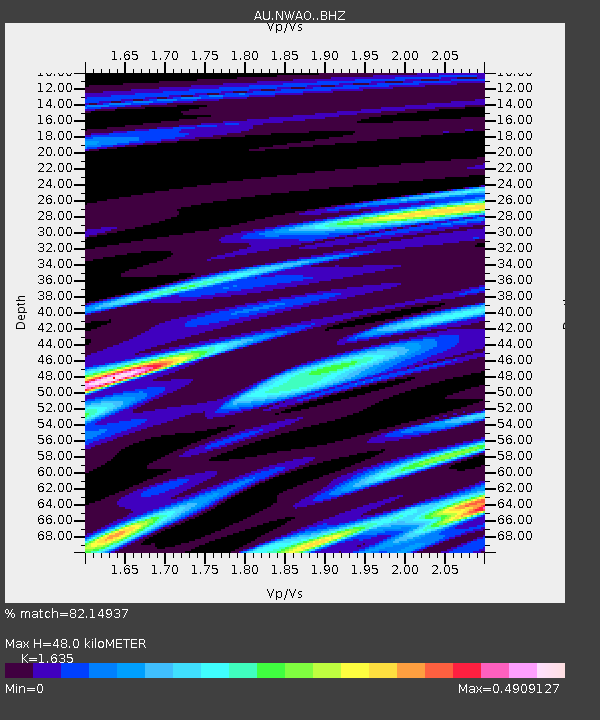
| Estimated Moho Depth: |
48.0 km |
| Estimated Crust Vp/Vs: |
1.63 |
| Assumed Crust Vp: |
6.419 km/s |
| Estimated Crust Vs: |
3.926 km/s |
| Estimated Crust Poisson's Ratio: |
0.20 |
|
| Radial Match: |
82.14937 % |
| Radial Bump: |
328 |
| Transverse Match: |
48.283207 % |
| Transverse Bump: |
400 |
| SOD ConfigId: |
28764291 |
| Insert Time: |
2022-10-27 22:28:01.643 +0000 |
| GWidth: |
2.5 |
| Max Bumps: |
400 |
| Tol: |
0.001 |
|

Signal To Noise
| Channel | StoN | STA | LTA |
| AU:NWAO: :BHZ:20221013T22:27:50.175006Z | 4.7098327 | 2.515758E-6 | 5.341502E-7 |
| AU:NWAO: :BH1:20221013T22:27:50.175006Z | 2.776076 | 1.1315285E-6 | 4.0759994E-7 |
| AU:NWAO: :BH2:20221013T22:27:50.175006Z | 2.325366 | 1.0521195E-6 | 4.524533E-7 |
| Arrivals |
| Ps | 5.1 SECOND |
| PpPs | 18 SECOND |
| PsPs/PpSs | 23 SECOND |


