You are here: Home > Network List > CN - Canadian National Seismograph Network Stations List
> Station TXDB Texada, BC, CA > Earthquake Result Viewer
TXDB Texada, BC, CA - Earthquake Result Viewer
| Earthquake location: |
New Ireland Region, P.N.G. |
| Earthquake latitude/longitude: |
-4.8/153.6 |
| Earthquake time(UTC): |
2022/10/13 (286) 22:20:20 GMT |
| Earthquake Depth: |
71 km |
| Earthquake Magnitude: |
6.4 mww |
| Earthquake Catalog/Contributor: |
NEIC PDE/us |
|
| Network: |
CN Canadian National Seismograph Network |
| Station: |
TXDB Texada, BC, CA |
| Lat/Lon: |
49.70 N/124.44 W |
| Elevation: |
501 m |
|
| Distance: |
88.5 deg |
| Az: |
40.036 deg |
| Baz: |
260.83 deg |
| Ray Param: |
0.042434856 |
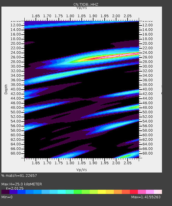
| Estimated Moho Depth: |
25.0 km |
| Estimated Crust Vp/Vs: |
2.01 |
| Assumed Crust Vp: |
6.391 km/s |
| Estimated Crust Vs: |
3.175 km/s |
| Estimated Crust Poisson's Ratio: |
0.34 |
|
| Radial Match: |
81.22657 % |
| Radial Bump: |
400 |
| Transverse Match: |
59.734787 % |
| Transverse Bump: |
400 |
| SOD ConfigId: |
28764291 |
| Insert Time: |
2022-10-27 22:36:47.113 +0000 |
| GWidth: |
2.5 |
| Max Bumps: |
400 |
| Tol: |
0.001 |
|

Signal To Noise
| Channel | StoN | STA | LTA |
| CN:TXDB: :HHZ:20221013T22:32:34.080004Z | 5.1283836 | 7.178314E-7 | 1.3997224E-7 |
| CN:TXDB: :HHN:20221013T22:32:34.080004Z | 0.71267325 | 7.865819E-8 | 1.1037062E-7 |
| CN:TXDB: :HHE:20221013T22:32:34.080004Z | 1.4636468 | 3.073523E-7 | 2.0999077E-7 |
| Arrivals |
| Ps | 4.0 SECOND |
| PpPs | 12 SECOND |
| PsPs/PpSs | 16 SECOND |


