You are here: Home > Network List > G - GEOSCOPE Stations List
> Station KIP Kipapa, Hawai, U.S.A. (Pacific Ocean) > Earthquake Result Viewer
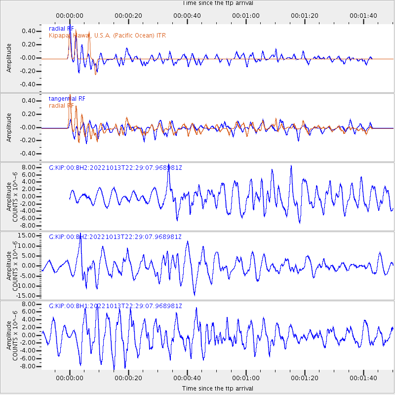
KIP Kipapa, Hawai, U.S.A. (Pacific Ocean) - Earthquake Result Viewer
*The percent match for this event was below the threshold and hence no stack was calculated.
| Earthquake location: |
New Ireland Region, P.N.G. |
| Earthquake latitude/longitude: |
-4.8/153.6 |
| Earthquake time(UTC): |
2022/10/13 (286) 22:20:20 GMT |
| Earthquake Depth: |
71 km |
| Earthquake Magnitude: |
6.4 mww |
| Earthquake Catalog/Contributor: |
NEIC PDE/us |
|
| Network: |
G GEOSCOPE |
| Station: |
KIP Kipapa, Hawai, U.S.A. (Pacific Ocean) |
| Lat/Lon: |
21.42 N/158.01 W |
| Elevation: |
70 m |
|
| Distance: |
54.1 deg |
| Az: |
59.341 deg |
| Baz: |
246.934 deg |
| Ray Param: |
$rayparam |
*The percent match for this event was below the threshold and hence was not used in the summary stack. |
|
| Radial Match: |
62.077503 % |
| Radial Bump: |
400 |
| Transverse Match: |
58.44066 % |
| Transverse Bump: |
400 |
| SOD ConfigId: |
28764291 |
| Insert Time: |
2022-10-27 22:37:22.350 +0000 |
| GWidth: |
2.5 |
| Max Bumps: |
400 |
| Tol: |
0.001 |
|
Signal To Noise
| Channel | StoN | STA | LTA |
| G:KIP:00:BHZ:20221013T22:29:07.968981Z | 3.436601 | 6.297468E-6 | 1.83247E-6 |
| G:KIP:00:BH1:20221013T22:29:07.968981Z | 1.580131 | 3.0158055E-6 | 1.9085794E-6 |
| G:KIP:00:BH2:20221013T22:29:07.968981Z | 2.5291867 | 3.3534407E-6 | 1.3258967E-6 |
| Arrivals |
| Ps | |
| PpPs | |
| PsPs/PpSs | |


