You are here: Home > Network List > XA95 - Missouri to Massachusetts Transect Stations List
> Station MM06 Emporium, Pennsylvania > Earthquake Result Viewer
MM06 Emporium, Pennsylvania - Earthquake Result Viewer
| Earthquake location: |
Kuril Islands |
| Earthquake latitude/longitude: |
45.9/151.3 |
| Earthquake time(UTC): |
1995/04/17 (107) 23:28:08 GMT |
| Earthquake Depth: |
34 km |
| Earthquake Magnitude: |
6.1 MB, 6.3 MS, 6.2 UNKNOWN, 6.8 MW |
| Earthquake Catalog/Contributor: |
WHDF/NEIC |
|
| Network: |
XA Missouri to Massachusetts Transect |
| Station: |
MM06 Emporium, Pennsylvania |
| Lat/Lon: |
41.39 N/78.13 W |
| Elevation: |
647 m |
|
| Distance: |
82.5 deg |
| Az: |
35.189 deg |
| Baz: |
327.669 deg |
| Ray Param: |
0.046765786 |
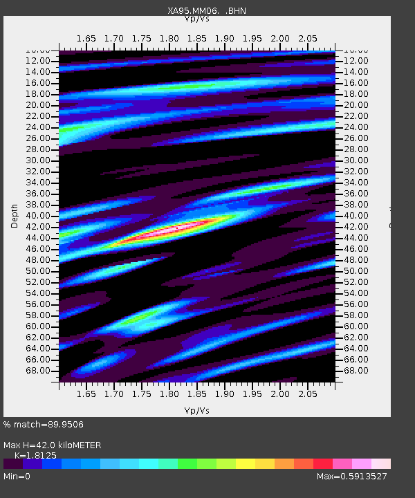
| Estimated Moho Depth: |
42.0 km |
| Estimated Crust Vp/Vs: |
1.81 |
| Assumed Crust Vp: |
6.121 km/s |
| Estimated Crust Vs: |
3.377 km/s |
| Estimated Crust Poisson's Ratio: |
0.28 |
|
| Radial Match: |
89.9506 % |
| Radial Bump: |
380 |
| Transverse Match: |
78.54184 % |
| Transverse Bump: |
400 |
| SOD ConfigId: |
6273 |
| Insert Time: |
2010-02-26 17:46:58.790 +0000 |
| GWidth: |
2.5 |
| Max Bumps: |
400 |
| Tol: |
0.001 |
|

Signal To Noise
| Channel | StoN | STA | LTA |
| XA:MM06: :BHN:19950417T23:39:56.581006Z | 3.2808373 | 7.7022776E-7 | 2.3476562E-7 |
| XA:MM06: :BHE:19950417T23:39:56.581006Z | 3.9557383 | 5.5100907E-7 | 1.3929362E-7 |
| XA:MM06: :BHZ:19950417T23:39:56.581006Z | 10.939326 | 2.6186974E-6 | 2.393838E-7 |
| Arrivals |
| Ps | 5.7 SECOND |
| PpPs | 19 SECOND |
| PsPs/PpSs | 25 SECOND |


