You are here: Home > Network List > US - United States National Seismic Network Stations List
> Station CBKS Cedar Bluff, Kansas, USA > Earthquake Result Viewer
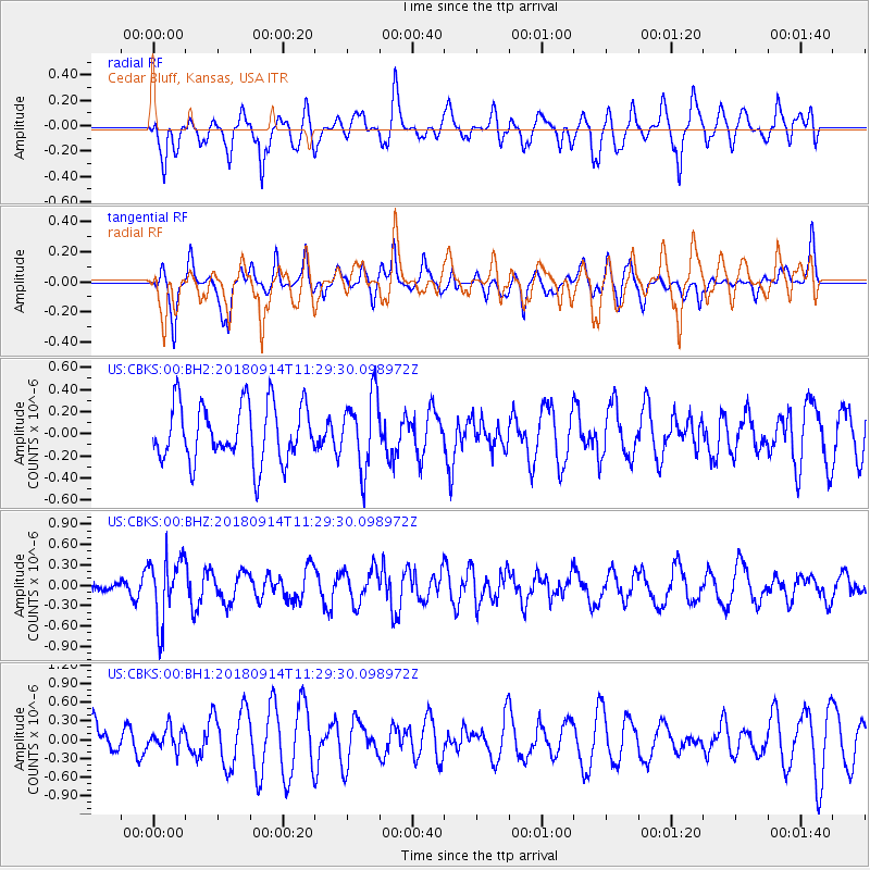
CBKS Cedar Bluff, Kansas, USA - Earthquake Result Viewer
*The percent match for this event was below the threshold and hence no stack was calculated.
| Earthquake location: |
Southern Peru |
| Earthquake latitude/longitude: |
-16.0/-71.5 |
| Earthquake time(UTC): |
2018/09/14 (257) 11:20:02 GMT |
| Earthquake Depth: |
121 km |
| Earthquake Magnitude: |
5.4 Mww |
| Earthquake Catalog/Contributor: |
NEIC PDE/us |
|
| Network: |
US United States National Seismic Network |
| Station: |
CBKS Cedar Bluff, Kansas, USA |
| Lat/Lon: |
38.81 N/99.74 W |
| Elevation: |
677 m |
|
| Distance: |
60.6 deg |
| Az: |
334.906 deg |
| Baz: |
148.535 deg |
| Ray Param: |
$rayparam |
*The percent match for this event was below the threshold and hence was not used in the summary stack. |
|
| Radial Match: |
72.302055 % |
| Radial Bump: |
400 |
| Transverse Match: |
51.53963 % |
| Transverse Bump: |
365 |
| SOD ConfigId: |
2825771 |
| Insert Time: |
2018-09-28 11:28:06.539 +0000 |
| GWidth: |
2.5 |
| Max Bumps: |
400 |
| Tol: |
0.001 |
|
Signal To Noise
| Channel | StoN | STA | LTA |
| US:CBKS:00:BHZ:20180914T11:29:30.098972Z | 2.398757 | 4.7286892E-7 | 1.9713082E-7 |
| US:CBKS:00:BH1:20180914T11:29:30.098972Z | 0.5055148 | 1.7099677E-7 | 3.3826265E-7 |
| US:CBKS:00:BH2:20180914T11:29:30.098972Z | 1.278588 | 3.3179057E-7 | 2.5949763E-7 |
| Arrivals |
| Ps | |
| PpPs | |
| PsPs/PpSs | |


