You are here: Home > Network List > UW - Pacific Northwest Regional Seismic Network Stations List
> Station INGAL Weyerhaeuser Pe Ell Tree Farm, Lewis County, WA, USA > Earthquake Result Viewer
INGAL Weyerhaeuser Pe Ell Tree Farm, Lewis County, WA, USA - Earthquake Result Viewer
| Earthquake location: |
New Ireland Region, P.N.G. |
| Earthquake latitude/longitude: |
-4.8/153.6 |
| Earthquake time(UTC): |
2022/10/13 (286) 22:20:20 GMT |
| Earthquake Depth: |
71 km |
| Earthquake Magnitude: |
6.4 mww |
| Earthquake Catalog/Contributor: |
NEIC PDE/us |
|
| Network: |
UW Pacific Northwest Regional Seismic Network |
| Station: |
INGAL Weyerhaeuser Pe Ell Tree Farm, Lewis County, WA, USA |
| Lat/Lon: |
46.72 N/123.18 W |
| Elevation: |
159 m |
|
| Distance: |
88.8 deg |
| Az: |
43.108 deg |
| Baz: |
261.836 deg |
| Ray Param: |
0.042158768 |
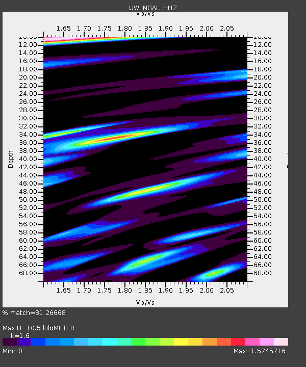
| Estimated Moho Depth: |
10.5 km |
| Estimated Crust Vp/Vs: |
1.60 |
| Assumed Crust Vp: |
6.566 km/s |
| Estimated Crust Vs: |
4.104 km/s |
| Estimated Crust Poisson's Ratio: |
0.18 |
|
| Radial Match: |
81.26668 % |
| Radial Bump: |
400 |
| Transverse Match: |
60.63966 % |
| Transverse Bump: |
400 |
| SOD ConfigId: |
28764291 |
| Insert Time: |
2022-10-27 22:50:14.903 +0000 |
| GWidth: |
2.5 |
| Max Bumps: |
400 |
| Tol: |
0.001 |
|

Signal To Noise
| Channel | StoN | STA | LTA |
| UW:INGAL: :HHZ:20221013T22:32:35.869982Z | 7.519966 | 7.9391543E-7 | 1.0557433E-7 |
| UW:INGAL: :HHN:20221013T22:32:35.869982Z | 1.282048 | 2.2979862E-7 | 1.7924337E-7 |
| UW:INGAL: :HHE:20221013T22:32:35.869982Z | 2.6902678 | 4.4368966E-7 | 1.6492397E-7 |
| Arrivals |
| Ps | 1.0 SECOND |
| PpPs | 4.1 SECOND |
| PsPs/PpSs | 5.0 SECOND |


