You are here: Home > Network List > IU - Global Seismograph Network (GSN - IRIS/USGS) Stations List
> Station PMG Port Moresby, New Guinea > Earthquake Result Viewer
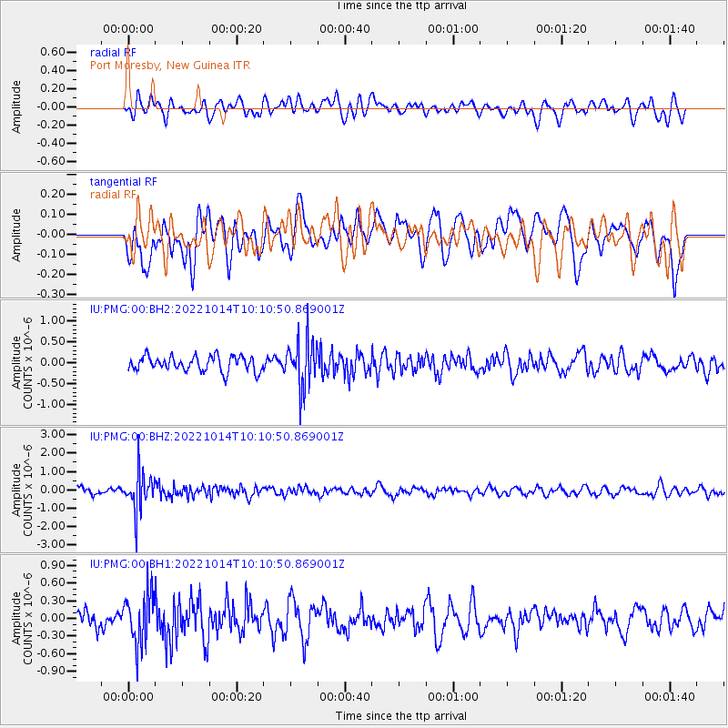
PMG Port Moresby, New Guinea - Earthquake Result Viewer
*The percent match for this event was below the threshold and hence no stack was calculated.
| Earthquake location: |
Fiji Islands Region |
| Earthquake latitude/longitude: |
-20.9/-178.7 |
| Earthquake time(UTC): |
2022/10/14 (287) 10:05:17 GMT |
| Earthquake Depth: |
566 km |
| Earthquake Magnitude: |
5.5 Mww |
| Earthquake Catalog/Contributor: |
NEIC PDE/us |
|
| Network: |
IU Global Seismograph Network (GSN - IRIS/USGS) |
| Station: |
PMG Port Moresby, New Guinea |
| Lat/Lon: |
9.40 S/147.16 E |
| Elevation: |
90 m |
|
| Distance: |
34.8 deg |
| Az: |
284.0 deg |
| Baz: |
113.179 deg |
| Ray Param: |
$rayparam |
*The percent match for this event was below the threshold and hence was not used in the summary stack. |
|
| Radial Match: |
51.457897 % |
| Radial Bump: |
400 |
| Transverse Match: |
50.528633 % |
| Transverse Bump: |
400 |
| SOD ConfigId: |
28764291 |
| Insert Time: |
2022-10-28 10:18:17.244 +0000 |
| GWidth: |
2.5 |
| Max Bumps: |
400 |
| Tol: |
0.001 |
|
Signal To Noise
| Channel | StoN | STA | LTA |
| IU:PMG:00:BHZ:20221014T10:10:50.869001Z | 5.885771 | 1.034677E-6 | 1.7579295E-7 |
| IU:PMG:00:BH1:20221014T10:10:50.869001Z | 2.141952 | 4.3254587E-7 | 2.0194004E-7 |
| IU:PMG:00:BH2:20221014T10:10:50.869001Z | 3.19222 | 5.710496E-7 | 1.7888793E-7 |
| Arrivals |
| Ps | |
| PpPs | |
| PsPs/PpSs | |


