You are here: Home > Network List > WY - Yellowstone Wyoming Seismic Network Stations List
> Station YHH Holmes Hill, YNP, WY, USA > Earthquake Result Viewer
YHH Holmes Hill, YNP, WY, USA - Earthquake Result Viewer
*The percent match for this event was below the threshold and hence no stack was calculated.
| Earthquake location: |
Southern Peru |
| Earthquake latitude/longitude: |
-16.0/-71.5 |
| Earthquake time(UTC): |
2018/09/14 (257) 11:20:02 GMT |
| Earthquake Depth: |
121 km |
| Earthquake Magnitude: |
5.4 Mww |
| Earthquake Catalog/Contributor: |
NEIC PDE/us |
|
| Network: |
WY Yellowstone Wyoming Seismic Network |
| Station: |
YHH Holmes Hill, YNP, WY, USA |
| Lat/Lon: |
44.79 N/110.85 W |
| Elevation: |
2717 m |
|
| Distance: |
70.3 deg |
| Az: |
331.348 deg |
| Baz: |
139.65 deg |
| Ray Param: |
$rayparam |
*The percent match for this event was below the threshold and hence was not used in the summary stack. |
|
| Radial Match: |
62.285233 % |
| Radial Bump: |
400 |
| Transverse Match: |
57.84472 % |
| Transverse Bump: |
400 |
| SOD ConfigId: |
2825771 |
| Insert Time: |
2018-09-28 11:29:40.657 +0000 |
| GWidth: |
2.5 |
| Max Bumps: |
400 |
| Tol: |
0.001 |
|
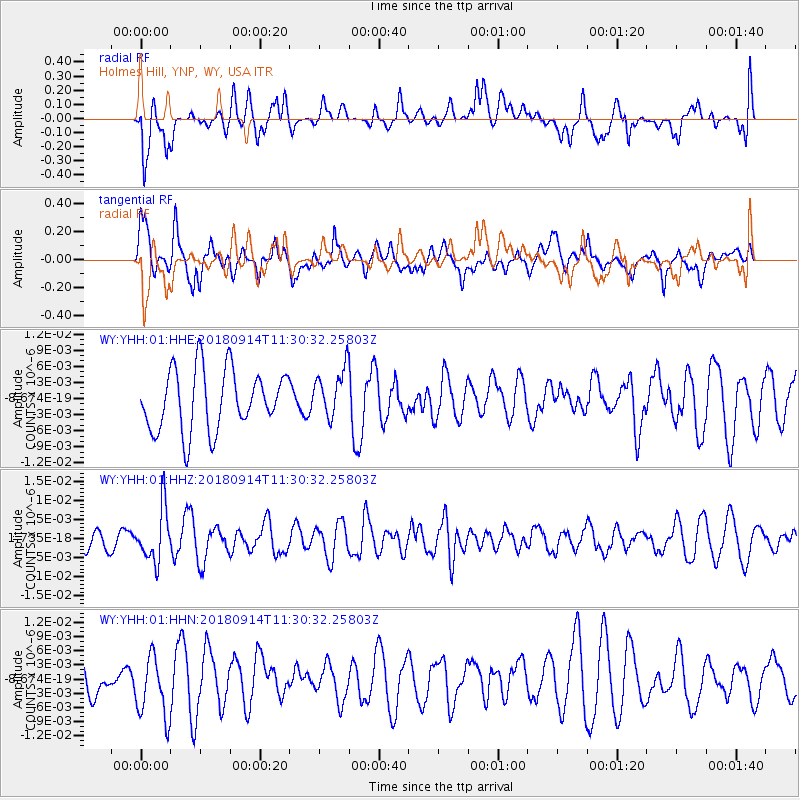
Signal To Noise
| Channel | StoN | STA | LTA |
| WY:YHH:01:HHZ:20180914T11:30:32.25803Z | 1.8427415 | 6.886643E-9 | 3.737173E-9 |
| WY:YHH:01:HHN:20180914T11:30:32.25803Z | 1.5838246 | 6.6142407E-9 | 4.1761195E-9 |
| WY:YHH:01:HHE:20180914T11:30:32.25803Z | 0.8055574 | 4.555102E-9 | 5.654596E-9 |
| Arrivals |
| Ps | |
| PpPs | |
| PsPs/PpSs | |


