You are here: Home > Network List > CC - Cascade Chain Volcano Monitoring Stations List
> Station SHRK Shell Rock, OR, USA > Earthquake Result Viewer
SHRK Shell Rock, OR, USA - Earthquake Result Viewer
| Earthquake location: |
Off Coast Of Central America |
| Earthquake latitude/longitude: |
4.4/-87.5 |
| Earthquake time(UTC): |
2022/10/16 (289) 12:48:21 GMT |
| Earthquake Depth: |
10 km |
| Earthquake Magnitude: |
6.3 Mww |
| Earthquake Catalog/Contributor: |
NEIC PDE/us |
|
| Network: |
CC Cascade Chain Volcano Monitoring |
| Station: |
SHRK Shell Rock, OR, USA |
| Lat/Lon: |
45.46 N/121.53 W |
| Elevation: |
1319 m |
|
| Distance: |
50.5 deg |
| Az: |
329.344 deg |
| Baz: |
133.744 deg |
| Ray Param: |
0.06798837 |
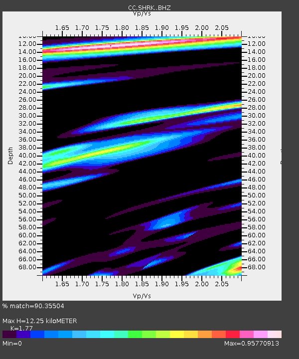
| Estimated Moho Depth: |
12.25 km |
| Estimated Crust Vp/Vs: |
1.77 |
| Assumed Crust Vp: |
6.597 km/s |
| Estimated Crust Vs: |
3.727 km/s |
| Estimated Crust Poisson's Ratio: |
0.27 |
|
| Radial Match: |
90.35504 % |
| Radial Bump: |
400 |
| Transverse Match: |
83.20257 % |
| Transverse Bump: |
400 |
| SOD ConfigId: |
28764291 |
| Insert Time: |
2022-10-30 13:02:09.720 +0000 |
| GWidth: |
2.5 |
| Max Bumps: |
400 |
| Tol: |
0.001 |
|

Signal To Noise
| Channel | StoN | STA | LTA |
| CC:SHRK: :BHZ:20221016T12:56:49.480014Z | 14.646116 | 2.6034659E-6 | 1.7775811E-7 |
| CC:SHRK: :BHN:20221016T12:56:49.480014Z | 2.92397 | 9.511836E-7 | 3.2530554E-7 |
| CC:SHRK: :BHE:20221016T12:56:49.480014Z | 5.19338 | 1.0560302E-6 | 2.0334163E-7 |
| Arrivals |
| Ps | 1.5 SECOND |
| PpPs | 4.8 SECOND |
| PsPs/PpSs | 6.4 SECOND |


