You are here: Home > Network List > CI - Caltech Regional Seismic Network Stations List
> Station MPP McPhearson Peak > Earthquake Result Viewer
MPP McPhearson Peak - Earthquake Result Viewer
| Earthquake location: |
Off Coast Of Central America |
| Earthquake latitude/longitude: |
4.4/-87.5 |
| Earthquake time(UTC): |
2022/10/16 (289) 12:48:21 GMT |
| Earthquake Depth: |
10 km |
| Earthquake Magnitude: |
6.3 Mww |
| Earthquake Catalog/Contributor: |
NEIC PDE/us |
|
| Network: |
CI Caltech Regional Seismic Network |
| Station: |
MPP McPhearson Peak |
| Lat/Lon: |
34.89 N/119.81 W |
| Elevation: |
1739 m |
|
| Distance: |
42.6 deg |
| Az: |
319.543 deg |
| Baz: |
128.088 deg |
| Ray Param: |
0.07307926 |
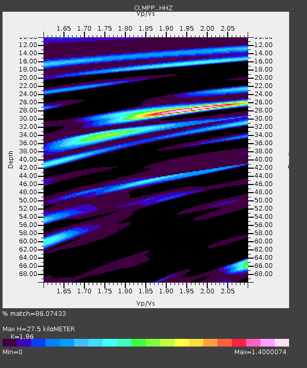
| Estimated Moho Depth: |
27.5 km |
| Estimated Crust Vp/Vs: |
1.96 |
| Assumed Crust Vp: |
6.1 km/s |
| Estimated Crust Vs: |
3.112 km/s |
| Estimated Crust Poisson's Ratio: |
0.32 |
|
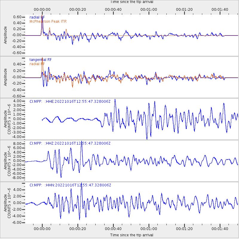
| Radial Match: |
86.07433 % |
| Radial Bump: |
391 |
| Transverse Match: |
69.59583 % |
| Transverse Bump: |
400 |
| SOD ConfigId: |
28764291 |
| Insert Time: |
2022-10-30 13:04:10.077 +0000 |
| GWidth: |
2.5 |
| Max Bumps: |
400 |
| Tol: |
0.001 |
|
Signal To Noise
| Channel | StoN | STA | LTA |
| CI:MPP: :HHZ:20221016T12:55:47.328006Z | 10.509135 | 1.7140975E-6 | 1.6310548E-7 |
| CI:MPP: :HHN:20221016T12:55:47.328006Z | 1.7518088 | 5.6386904E-7 | 3.2187816E-7 |
| CI:MPP: :HHE:20221016T12:55:47.328006Z | 2.294495 | 7.5546546E-7 | 3.292513E-7 |
| Arrivals |
| Ps | 4.6 SECOND |
| PpPs | 13 SECOND |
| PsPs/PpSs | 17 SECOND |


