You are here: Home > Network List > IU - Global Seismograph Network (GSN - IRIS/USGS) Stations List
> Station PMG Port Moresby, New Guinea > Earthquake Result Viewer
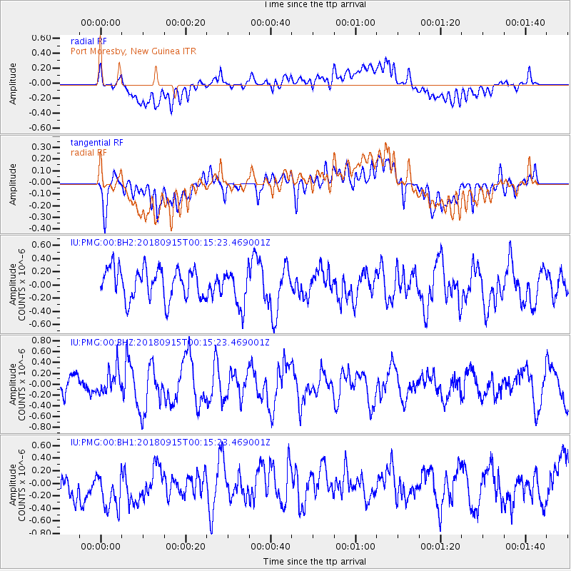
PMG Port Moresby, New Guinea - Earthquake Result Viewer
*The percent match for this event was below the threshold and hence no stack was calculated.
| Earthquake location: |
Ryukyu Islands, Japan |
| Earthquake latitude/longitude: |
26.7/129.6 |
| Earthquake time(UTC): |
2018/09/15 (258) 00:08:20 GMT |
| Earthquake Depth: |
5.9 km |
| Earthquake Magnitude: |
5.6 Mww |
| Earthquake Catalog/Contributor: |
NEIC PDE/us |
|
| Network: |
IU Global Seismograph Network (GSN - IRIS/USGS) |
| Station: |
PMG Port Moresby, New Guinea |
| Lat/Lon: |
9.40 S/147.16 E |
| Elevation: |
90 m |
|
| Distance: |
39.7 deg |
| Az: |
152.331 deg |
| Baz: |
335.112 deg |
| Ray Param: |
$rayparam |
*The percent match for this event was below the threshold and hence was not used in the summary stack. |
|
| Radial Match: |
32.750378 % |
| Radial Bump: |
400 |
| Transverse Match: |
51.819355 % |
| Transverse Bump: |
400 |
| SOD ConfigId: |
2825771 |
| Insert Time: |
2018-09-29 00:27:49.666 +0000 |
| GWidth: |
2.5 |
| Max Bumps: |
400 |
| Tol: |
0.001 |
|
Signal To Noise
| Channel | StoN | STA | LTA |
| IU:PMG:00:BHZ:20180915T00:15:23.469001Z | 1.161441 | 2.3287735E-7 | 2.0050726E-7 |
| IU:PMG:00:BH1:20180915T00:15:23.469001Z | 1.1293565 | 6.3219176E-7 | 5.597806E-7 |
| IU:PMG:00:BH2:20180915T00:15:23.469001Z | 1.2475528 | 2.910428E-7 | 2.3329096E-7 |
| Arrivals |
| Ps | |
| PpPs | |
| PsPs/PpSs | |


