You are here: Home > Network List > GM - US Geological Survey Networks Stations List
> Station NMP11 New Mexico Permian - Site# W1S1 > Earthquake Result Viewer
NMP11 New Mexico Permian - Site# W1S1 - Earthquake Result Viewer
| Earthquake location: |
Off Coast Of Central America |
| Earthquake latitude/longitude: |
4.4/-87.5 |
| Earthquake time(UTC): |
2022/10/16 (289) 12:48:21 GMT |
| Earthquake Depth: |
10 km |
| Earthquake Magnitude: |
6.3 Mww |
| Earthquake Catalog/Contributor: |
NEIC PDE/us |
|
| Network: |
GM US Geological Survey Networks |
| Station: |
NMP11 New Mexico Permian - Site# W1S1 |
| Lat/Lon: |
32.01 N/103.93 W |
| Elevation: |
883 m |
|
| Distance: |
31.5 deg |
| Az: |
332.647 deg |
| Baz: |
147.367 deg |
| Ray Param: |
0.07904977 |
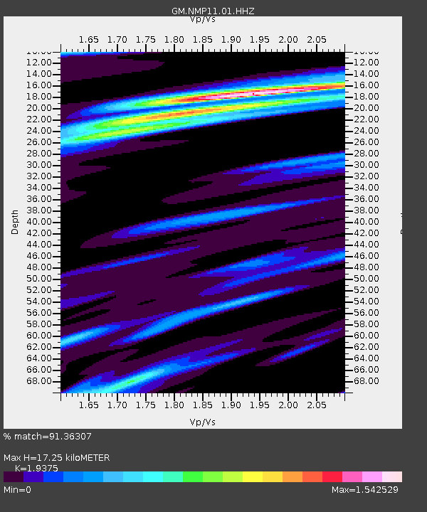
| Estimated Moho Depth: |
17.25 km |
| Estimated Crust Vp/Vs: |
1.94 |
| Assumed Crust Vp: |
6.129 km/s |
| Estimated Crust Vs: |
3.163 km/s |
| Estimated Crust Poisson's Ratio: |
0.32 |
|
| Radial Match: |
91.36307 % |
| Radial Bump: |
399 |
| Transverse Match: |
68.56244 % |
| Transverse Bump: |
400 |
| SOD ConfigId: |
28764291 |
| Insert Time: |
2022-10-30 13:10:04.842 +0000 |
| GWidth: |
2.5 |
| Max Bumps: |
400 |
| Tol: |
0.001 |
|

Signal To Noise
| Channel | StoN | STA | LTA |
| GM:NMP11:01:HHZ:20221016T12:54:13.29999Z | 7.726298 | 2.5812913E-6 | 3.340916E-7 |
| GM:NMP11:01:HHN:20221016T12:54:13.29999Z | 4.888407 | 1.0698852E-6 | 2.1886173E-7 |
| GM:NMP11:01:HHE:20221016T12:54:13.29999Z | 4.771784 | 1.0122217E-6 | 2.1212648E-7 |
| Arrivals |
| Ps | 2.8 SECOND |
| PpPs | 7.7 SECOND |
| PsPs/PpSs | 11 SECOND |


