You are here: Home > Network List > GS - US Geological Survey Networks Stations List
> Station OK052 Battle Ridge Rd, NW of Cushing, Oklahoma USA > Earthquake Result Viewer
OK052 Battle Ridge Rd, NW of Cushing, Oklahoma USA - Earthquake Result Viewer
| Earthquake location: |
Off Coast Of Central America |
| Earthquake latitude/longitude: |
4.4/-87.5 |
| Earthquake time(UTC): |
2022/10/16 (289) 12:48:21 GMT |
| Earthquake Depth: |
10 km |
| Earthquake Magnitude: |
6.3 Mww |
| Earthquake Catalog/Contributor: |
NEIC PDE/us |
|
| Network: |
GS US Geological Survey Networks |
| Station: |
OK052 Battle Ridge Rd, NW of Cushing, Oklahoma USA |
| Lat/Lon: |
36.00 N/96.80 W |
| Elevation: |
261 m |
|
| Distance: |
32.6 deg |
| Az: |
345.945 deg |
| Baz: |
162.626 deg |
| Ray Param: |
0.07858886 |
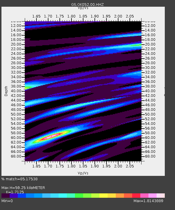
| Estimated Moho Depth: |
59.25 km |
| Estimated Crust Vp/Vs: |
1.71 |
| Assumed Crust Vp: |
6.426 km/s |
| Estimated Crust Vs: |
3.752 km/s |
| Estimated Crust Poisson's Ratio: |
0.24 |
|
| Radial Match: |
85.17538 % |
| Radial Bump: |
302 |
| Transverse Match: |
69.371414 % |
| Transverse Bump: |
400 |
| SOD ConfigId: |
28764291 |
| Insert Time: |
2022-10-30 13:10:51.969 +0000 |
| GWidth: |
2.5 |
| Max Bumps: |
400 |
| Tol: |
0.001 |
|

Signal To Noise
| Channel | StoN | STA | LTA |
| GS:OK052:00:HHZ:20221016T12:54:22.959994Z | 15.267384 | 2.1852818E-6 | 1.43134E-7 |
| GS:OK052:00:HH1:20221016T12:54:22.959994Z | 9.797508 | 1.439431E-6 | 1.4691808E-7 |
| GS:OK052:00:HH2:20221016T12:54:22.959994Z | 3.2828238 | 8.0289703E-7 | 2.4457515E-7 |
| Arrivals |
| Ps | 7.1 SECOND |
| PpPs | 23 SECOND |
| PsPs/PpSs | 30 SECOND |


