You are here: Home > Network List > US - United States National Seismic Network Stations List
> Station MSO Missoula, Montana, USA > Earthquake Result Viewer
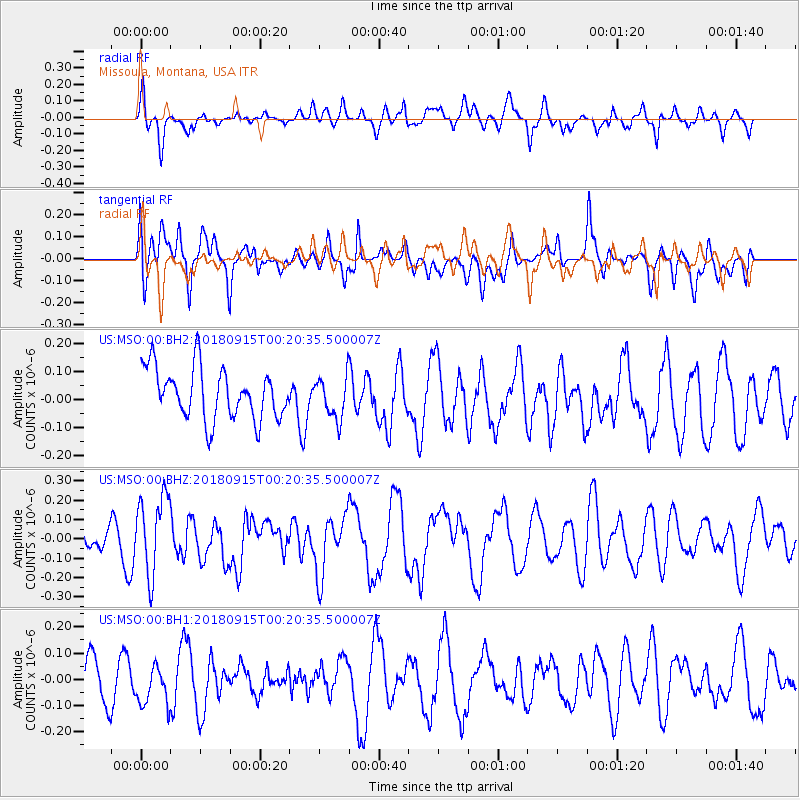
MSO Missoula, Montana, USA - Earthquake Result Viewer
*The percent match for this event was below the threshold and hence no stack was calculated.
| Earthquake location: |
Ryukyu Islands, Japan |
| Earthquake latitude/longitude: |
26.7/129.6 |
| Earthquake time(UTC): |
2018/09/15 (258) 00:08:20 GMT |
| Earthquake Depth: |
5.9 km |
| Earthquake Magnitude: |
5.6 Mww |
| Earthquake Catalog/Contributor: |
NEIC PDE/us |
|
| Network: |
US United States National Seismic Network |
| Station: |
MSO Missoula, Montana, USA |
| Lat/Lon: |
46.83 N/113.94 W |
| Elevation: |
1264 m |
|
| Distance: |
87.0 deg |
| Az: |
38.009 deg |
| Baz: |
306.677 deg |
| Ray Param: |
$rayparam |
*The percent match for this event was below the threshold and hence was not used in the summary stack. |
|
| Radial Match: |
46.96077 % |
| Radial Bump: |
400 |
| Transverse Match: |
50.442947 % |
| Transverse Bump: |
400 |
| SOD ConfigId: |
2825771 |
| Insert Time: |
2018-09-29 00:29:20.717 +0000 |
| GWidth: |
2.5 |
| Max Bumps: |
400 |
| Tol: |
0.001 |
|
Signal To Noise
| Channel | StoN | STA | LTA |
| US:MSO:00:BHZ:20180915T00:20:35.500007Z | 2.101396 | 2.0523558E-7 | 9.76663E-8 |
| US:MSO:00:BH1:20180915T00:20:35.500007Z | 0.8612594 | 8.1502876E-8 | 9.46322E-8 |
| US:MSO:00:BH2:20180915T00:20:35.500007Z | 0.8135189 | 7.429892E-8 | 9.13303E-8 |
| Arrivals |
| Ps | |
| PpPs | |
| PsPs/PpSs | |


