You are here: Home > Network List > N4 - Central and EAstern US Network Stations List
> Station W52A Murphy, NC, USA > Earthquake Result Viewer
W52A Murphy, NC, USA - Earthquake Result Viewer
| Earthquake location: |
Off Coast Of Central America |
| Earthquake latitude/longitude: |
4.4/-87.5 |
| Earthquake time(UTC): |
2022/10/16 (289) 12:48:21 GMT |
| Earthquake Depth: |
10 km |
| Earthquake Magnitude: |
6.3 Mww |
| Earthquake Catalog/Contributor: |
NEIC PDE/us |
|
| Network: |
N4 Central and EAstern US Network |
| Station: |
W52A Murphy, NC, USA |
| Lat/Lon: |
35.09 N/83.93 W |
| Elevation: |
519 m |
|
| Distance: |
30.7 deg |
| Az: |
5.759 deg |
| Baz: |
187.009 deg |
| Ray Param: |
0.0793245 |
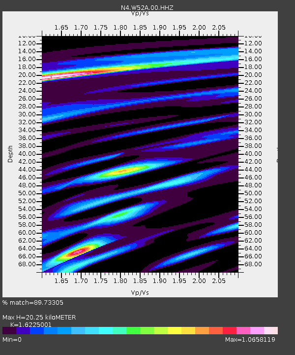
| Estimated Moho Depth: |
20.25 km |
| Estimated Crust Vp/Vs: |
1.62 |
| Assumed Crust Vp: |
6.35 km/s |
| Estimated Crust Vs: |
3.914 km/s |
| Estimated Crust Poisson's Ratio: |
0.19 |
|
| Radial Match: |
89.73305 % |
| Radial Bump: |
240 |
| Transverse Match: |
59.31316 % |
| Transverse Bump: |
368 |
| SOD ConfigId: |
28764291 |
| Insert Time: |
2022-10-30 13:15:12.094 +0000 |
| GWidth: |
2.5 |
| Max Bumps: |
400 |
| Tol: |
0.001 |
|

Signal To Noise
| Channel | StoN | STA | LTA |
| N4:W52A:00:HHZ:20221016T12:54:06.609988Z | 21.340496 | 1.8947817E-6 | 8.8788084E-8 |
| N4:W52A:00:HH1:20221016T12:54:06.609988Z | 16.494839 | 1.3585536E-6 | 8.236234E-8 |
| N4:W52A:00:HH2:20221016T12:54:06.609988Z | 2.683458 | 1.8879456E-7 | 7.035495E-8 |
| Arrivals |
| Ps | 2.2 SECOND |
| PpPs | 7.7 SECOND |
| PsPs/PpSs | 9.8 SECOND |


