You are here: Home > Network List > O2 - Oklahoma Consolidated Temporary Seismic Networks Stations List
> Station DOVR Dover, Oklahoma, USA > Earthquake Result Viewer
DOVR Dover, Oklahoma, USA - Earthquake Result Viewer
| Earthquake location: |
Off Coast Of Central America |
| Earthquake latitude/longitude: |
4.4/-87.5 |
| Earthquake time(UTC): |
2022/10/16 (289) 12:48:21 GMT |
| Earthquake Depth: |
10 km |
| Earthquake Magnitude: |
6.3 Mww |
| Earthquake Catalog/Contributor: |
NEIC PDE/us |
|
| Network: |
O2 Oklahoma Consolidated Temporary Seismic Networks |
| Station: |
DOVR Dover, Oklahoma, USA |
| Lat/Lon: |
35.95 N/97.99 W |
| Elevation: |
337 m |
|
| Distance: |
32.9 deg |
| Az: |
344.234 deg |
| Baz: |
160.493 deg |
| Ray Param: |
0.07846673 |
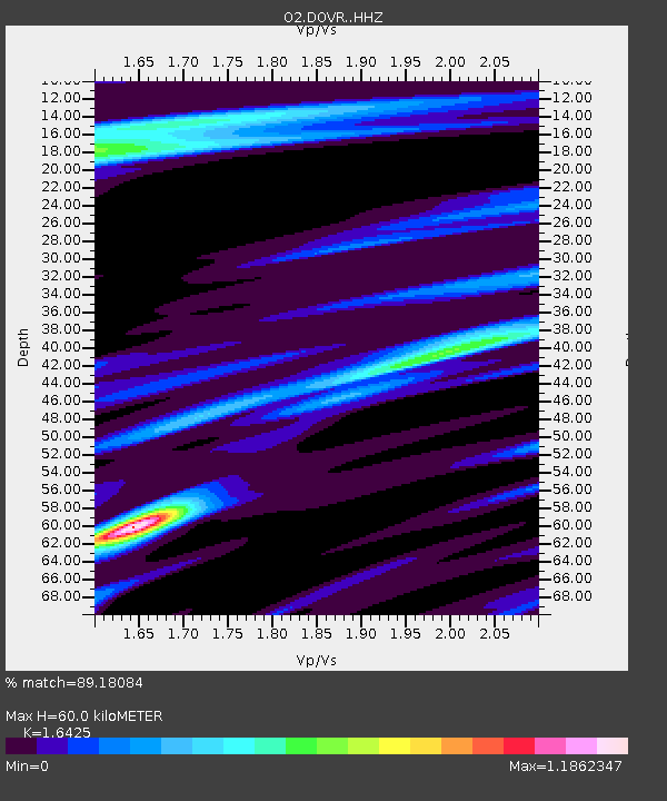
| Estimated Moho Depth: |
60.0 km |
| Estimated Crust Vp/Vs: |
1.64 |
| Assumed Crust Vp: |
6.426 km/s |
| Estimated Crust Vs: |
3.912 km/s |
| Estimated Crust Poisson's Ratio: |
0.21 |
|
| Radial Match: |
89.18084 % |
| Radial Bump: |
193 |
| Transverse Match: |
71.83928 % |
| Transverse Bump: |
297 |
| SOD ConfigId: |
28764291 |
| Insert Time: |
2022-10-30 13:17:48.072 +0000 |
| GWidth: |
2.5 |
| Max Bumps: |
400 |
| Tol: |
0.001 |
|

Signal To Noise
| Channel | StoN | STA | LTA |
| O2:DOVR: :HHZ:20221016T12:54:25.280001Z | 15.071524 | 2.8197328E-6 | 1.870901E-7 |
| O2:DOVR: :HHN:20221016T12:54:25.280001Z | 7.167301 | 9.482768E-7 | 1.3230598E-7 |
| O2:DOVR: :HHE:20221016T12:54:25.280001Z | 5.796141 | 8.8391346E-7 | 1.5250033E-7 |
| Arrivals |
| Ps | 6.5 SECOND |
| PpPs | 23 SECOND |
| PsPs/PpSs | 29 SECOND |


