You are here: Home > Network List > O2 - Oklahoma Consolidated Temporary Seismic Networks Stations List
> Station PW18 Morrison, Oklahoma, USA > Earthquake Result Viewer
PW18 Morrison, Oklahoma, USA - Earthquake Result Viewer
| Earthquake location: |
Off Coast Of Central America |
| Earthquake latitude/longitude: |
4.4/-87.5 |
| Earthquake time(UTC): |
2022/10/16 (289) 12:48:21 GMT |
| Earthquake Depth: |
10 km |
| Earthquake Magnitude: |
6.3 Mww |
| Earthquake Catalog/Contributor: |
NEIC PDE/us |
|
| Network: |
O2 Oklahoma Consolidated Temporary Seismic Networks |
| Station: |
PW18 Morrison, Oklahoma, USA |
| Lat/Lon: |
36.28 N/97.04 W |
| Elevation: |
299 m |
|
| Distance: |
32.9 deg |
| Az: |
345.757 deg |
| Baz: |
162.326 deg |
| Ray Param: |
0.07843825 |
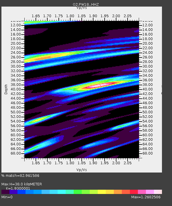
| Estimated Moho Depth: |
38.0 km |
| Estimated Crust Vp/Vs: |
1.93 |
| Assumed Crust Vp: |
6.483 km/s |
| Estimated Crust Vs: |
3.359 km/s |
| Estimated Crust Poisson's Ratio: |
0.32 |
|
| Radial Match: |
82.961586 % |
| Radial Bump: |
308 |
| Transverse Match: |
61.131767 % |
| Transverse Bump: |
328 |
| SOD ConfigId: |
28764291 |
| Insert Time: |
2022-10-30 13:18:29.666 +0000 |
| GWidth: |
2.5 |
| Max Bumps: |
400 |
| Tol: |
0.001 |
|

Signal To Noise
| Channel | StoN | STA | LTA |
| O2:PW18: :HHZ:20221016T12:54:25.834994Z | 28.264309 | 2.430006E-6 | 8.597436E-8 |
| O2:PW18: :HHN:20221016T12:54:25.834994Z | 8.851249 | 1.6527811E-6 | 1.8672857E-7 |
| O2:PW18: :HHE:20221016T12:54:25.834994Z | 3.6897626 | 8.2280627E-7 | 2.2299709E-7 |
| Arrivals |
| Ps | 5.9 SECOND |
| PpPs | 16 SECOND |
| PsPs/PpSs | 22 SECOND |


