You are here: Home > Network List > UO - University of Oregon Regional Network Stations List
> Station HBUG Ophir, OR, USA > Earthquake Result Viewer
HBUG Ophir, OR, USA - Earthquake Result Viewer
| Earthquake location: |
Off Coast Of Central America |
| Earthquake latitude/longitude: |
4.4/-87.5 |
| Earthquake time(UTC): |
2022/10/16 (289) 12:48:21 GMT |
| Earthquake Depth: |
10 km |
| Earthquake Magnitude: |
6.3 Mww |
| Earthquake Catalog/Contributor: |
NEIC PDE/us |
|
| Network: |
UO University of Oregon Regional Network |
| Station: |
HBUG Ophir, OR, USA |
| Lat/Lon: |
42.64 N/124.38 W |
| Elevation: |
388 m |
|
| Distance: |
50.2 deg |
| Az: |
324.831 deg |
| Baz: |
128.889 deg |
| Ray Param: |
0.06820135 |
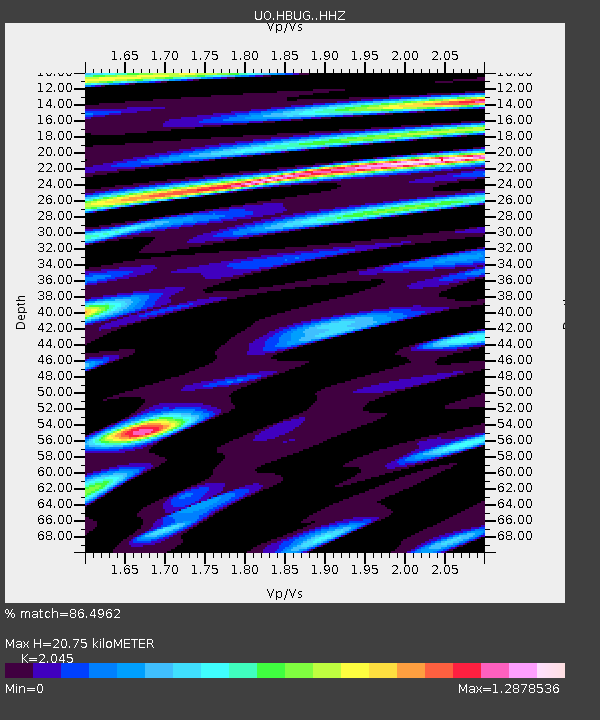
| Estimated Moho Depth: |
20.75 km |
| Estimated Crust Vp/Vs: |
2.05 |
| Assumed Crust Vp: |
6.048 km/s |
| Estimated Crust Vs: |
2.957 km/s |
| Estimated Crust Poisson's Ratio: |
0.34 |
|
| Radial Match: |
86.4962 % |
| Radial Bump: |
400 |
| Transverse Match: |
86.07069 % |
| Transverse Bump: |
400 |
| SOD ConfigId: |
28764291 |
| Insert Time: |
2022-10-30 13:24:45.891 +0000 |
| GWidth: |
2.5 |
| Max Bumps: |
400 |
| Tol: |
0.001 |
|

Signal To Noise
| Channel | StoN | STA | LTA |
| UO:HBUG: :HHZ:20221016T12:56:47.060Z | 10.747313 | 2.1181063E-6 | 1.970824E-7 |
| UO:HBUG: :HHN:20221016T12:56:47.060Z | 2.7740562 | 6.866257E-7 | 2.4751688E-7 |
| UO:HBUG: :HHE:20221016T12:56:47.060Z | 3.9083233 | 8.5788105E-7 | 2.1950103E-7 |
| Arrivals |
| Ps | 3.7 SECOND |
| PpPs | 10.0 SECOND |
| PsPs/PpSs | 14 SECOND |


