You are here: Home > Network List > UO - University of Oregon Regional Network Stations List
> Station RSBO Finn Rock, OR, USA > Earthquake Result Viewer
RSBO Finn Rock, OR, USA - Earthquake Result Viewer
| Earthquake location: |
Off Coast Of Central America |
| Earthquake latitude/longitude: |
4.4/-87.5 |
| Earthquake time(UTC): |
2022/10/16 (289) 12:48:21 GMT |
| Earthquake Depth: |
10 km |
| Earthquake Magnitude: |
6.3 Mww |
| Earthquake Catalog/Contributor: |
NEIC PDE/us |
|
| Network: |
UO University of Oregon Regional Network |
| Station: |
RSBO Finn Rock, OR, USA |
| Lat/Lon: |
44.04 N/122.27 W |
| Elevation: |
1235 m |
|
| Distance: |
50.0 deg |
| Az: |
327.525 deg |
| Baz: |
132.062 deg |
| Ray Param: |
0.06837684 |
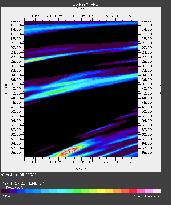
| Estimated Moho Depth: |
67.25 km |
| Estimated Crust Vp/Vs: |
1.80 |
| Assumed Crust Vp: |
6.566 km/s |
| Estimated Crust Vs: |
3.653 km/s |
| Estimated Crust Poisson's Ratio: |
0.28 |
|
| Radial Match: |
85.91932 % |
| Radial Bump: |
400 |
| Transverse Match: |
60.44733 % |
| Transverse Bump: |
400 |
| SOD ConfigId: |
28764291 |
| Insert Time: |
2022-10-30 13:25:20.265 +0000 |
| GWidth: |
2.5 |
| Max Bumps: |
400 |
| Tol: |
0.001 |
|

Signal To Noise
| Channel | StoN | STA | LTA |
| UO:RSBO: :HHZ:20221016T12:56:45.07001Z | 11.873127 | 1.6977469E-6 | 1.4299071E-7 |
| UO:RSBO: :HHN:20221016T12:56:45.07001Z | 1.7228537 | 8.757058E-7 | 5.08288E-7 |
| UO:RSBO: :HHE:20221016T12:56:45.07001Z | 1.7016692 | 9.046667E-7 | 5.316349E-7 |
| Arrivals |
| Ps | 8.7 SECOND |
| PpPs | 27 SECOND |
| PsPs/PpSs | 36 SECOND |


