You are here: Home > Network List > US - United States National Seismic Network Stations List
> Station MNTX Cornudas Mountains, Texas, USA > Earthquake Result Viewer
MNTX Cornudas Mountains, Texas, USA - Earthquake Result Viewer

| Earthquake location: |
Off Coast Of Central America |
| Earthquake latitude/longitude: |
4.4/-87.5 |
| Earthquake time(UTC): |
2022/10/16 (289) 12:48:21 GMT |
| Earthquake Depth: |
10 km |
| Earthquake Magnitude: |
6.3 Mww |
| Earthquake Catalog/Contributor: |
NEIC PDE/us |
|
| Network: |
US United States National Seismic Network |
| Station: |
MNTX Cornudas Mountains, Texas, USA |
| Lat/Lon: |
31.70 N/105.38 W |
| Elevation: |
405 m |
|
| Distance: |
31.9 deg |
| Az: |
330.374 deg |
| Baz: |
144.671 deg |
| Ray Param: |
0.078877985 |
| Estimated Moho Depth: |
60.75 km |
| Estimated Crust Vp/Vs: |
1.66 |
| Assumed Crust Vp: |
6.361 km/s |
| Estimated Crust Vs: |
3.832 km/s |
| Estimated Crust Poisson's Ratio: |
0.22 |
|
| Radial Match: |
94.10137 % |
| Radial Bump: |
238 |
| Transverse Match: |
87.39285 % |
| Transverse Bump: |
400 |
| SOD ConfigId: |
28764291 |
| Insert Time: |
2022-10-30 13:26:42.523 +0000 |
| GWidth: |
2.5 |
| Max Bumps: |
400 |
| Tol: |
0.001 |
|
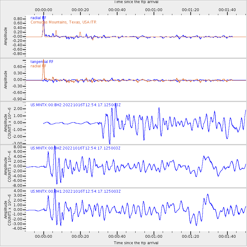
Signal To Noise
| Channel | StoN | STA | LTA |
| US:MNTX:00:BHZ:20221016T12:54:17.125003Z | 30.358896 | 2.4734363E-6 | 8.147319E-8 |
| US:MNTX:00:BH1:20221016T12:54:17.125003Z | 16.147724 | 1.247173E-6 | 7.723522E-8 |
| US:MNTX:00:BH2:20221016T12:54:17.125003Z | 9.570842 | 8.9112706E-7 | 9.310853E-8 |
| Arrivals |
| Ps | 6.9 SECOND |
| PpPs | 23 SECOND |
| PsPs/PpSs | 30 SECOND |


