You are here: Home > Network List > US - United States National Seismic Network Stations List
> Station OGNE Ogallala, Nebraska, USA > Earthquake Result Viewer
OGNE Ogallala, Nebraska, USA - Earthquake Result Viewer
| Earthquake location: |
Off Coast Of Central America |
| Earthquake latitude/longitude: |
4.4/-87.5 |
| Earthquake time(UTC): |
2022/10/16 (289) 12:48:21 GMT |
| Earthquake Depth: |
10 km |
| Earthquake Magnitude: |
6.3 Mww |
| Earthquake Catalog/Contributor: |
NEIC PDE/us |
|
| Network: |
US United States National Seismic Network |
| Station: |
OGNE Ogallala, Nebraska, USA |
| Lat/Lon: |
40.95 N/102.03 W |
| Elevation: |
1054 m |
|
| Distance: |
38.7 deg |
| Az: |
342.309 deg |
| Baz: |
156.421 deg |
| Ray Param: |
0.07545348 |
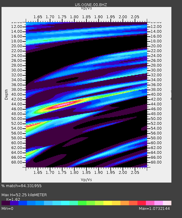
| Estimated Moho Depth: |
52.25 km |
| Estimated Crust Vp/Vs: |
1.62 |
| Assumed Crust Vp: |
6.483 km/s |
| Estimated Crust Vs: |
4.002 km/s |
| Estimated Crust Poisson's Ratio: |
0.19 |
|
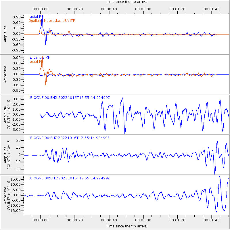
| Radial Match: |
94.331955 % |
| Radial Bump: |
263 |
| Transverse Match: |
50.976883 % |
| Transverse Bump: |
343 |
| SOD ConfigId: |
28764291 |
| Insert Time: |
2022-10-30 13:26:49.612 +0000 |
| GWidth: |
2.5 |
| Max Bumps: |
400 |
| Tol: |
0.001 |
|
Signal To Noise
| Channel | StoN | STA | LTA |
| US:OGNE:00:BHZ:20221016T12:55:14.92499Z | 16.75635 | 2.707219E-6 | 1.6156376E-7 |
| US:OGNE:00:BH1:20221016T12:55:14.92499Z | 3.8839478 | 1.4380987E-6 | 3.7026726E-7 |
| US:OGNE:00:BH2:20221016T12:55:14.92499Z | 2.4591432 | 8.728848E-7 | 3.5495484E-7 |
| Arrivals |
| Ps | 5.4 SECOND |
| PpPs | 19 SECOND |
| PsPs/PpSs | 25 SECOND |


