You are here: Home > Network List > UU - University of Utah Regional Network Stations List
> Station CCUT Cedar City, UT, USA > Earthquake Result Viewer
CCUT Cedar City, UT, USA - Earthquake Result Viewer

| Earthquake location: |
Off Coast Of Central America |
| Earthquake latitude/longitude: |
4.4/-87.5 |
| Earthquake time(UTC): |
2022/10/16 (289) 12:48:21 GMT |
| Earthquake Depth: |
10 km |
| Earthquake Magnitude: |
6.3 Mww |
| Earthquake Catalog/Contributor: |
NEIC PDE/us |
|
| Network: |
UU University of Utah Regional Network |
| Station: |
CCUT Cedar City, UT, USA |
| Lat/Lon: |
37.55 N/113.36 W |
| Elevation: |
2127 m |
|
| Distance: |
40.6 deg |
| Az: |
327.831 deg |
| Baz: |
138.09 deg |
| Ray Param: |
0.074305 |
| Estimated Moho Depth: |
36.75 km |
| Estimated Crust Vp/Vs: |
1.83 |
| Assumed Crust Vp: |
6.194 km/s |
| Estimated Crust Vs: |
3.38 km/s |
| Estimated Crust Poisson's Ratio: |
0.29 |
|
| Radial Match: |
91.258865 % |
| Radial Bump: |
400 |
| Transverse Match: |
76.07588 % |
| Transverse Bump: |
400 |
| SOD ConfigId: |
28764291 |
| Insert Time: |
2022-10-30 13:27:06.485 +0000 |
| GWidth: |
2.5 |
| Max Bumps: |
400 |
| Tol: |
0.001 |
|
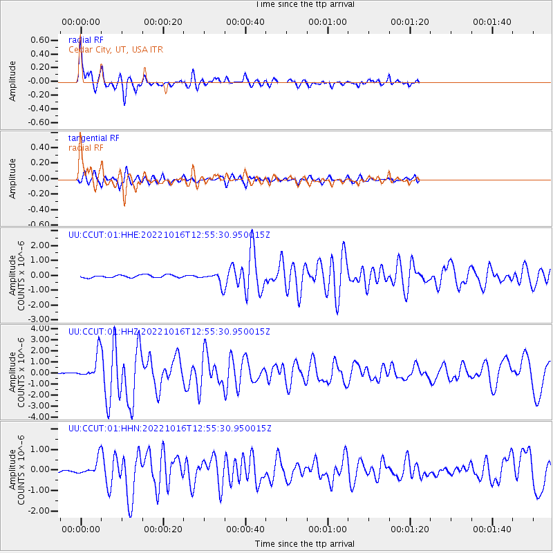
Signal To Noise
| Channel | StoN | STA | LTA |
| UU:CCUT:01:HHZ:20221016T12:55:30.950015Z | 19.633198 | 1.2166211E-6 | 6.196755E-8 |
| UU:CCUT:01:HHN:20221016T12:55:30.950015Z | 5.7511396 | 4.1432676E-7 | 7.204255E-8 |
| UU:CCUT:01:HHE:20221016T12:55:30.950015Z | 4.6924114 | 4.287466E-7 | 9.1370204E-8 |
| Arrivals |
| Ps | 5.3 SECOND |
| PpPs | 16 SECOND |
| PsPs/PpSs | 21 SECOND |


