You are here: Home > Network List > UW - Pacific Northwest Regional Seismic Network Stations List
> Station EPH2 Ephrata, WA, USA > Earthquake Result Viewer
EPH2 Ephrata, WA, USA - Earthquake Result Viewer
| Earthquake location: |
Off Coast Of Central America |
| Earthquake latitude/longitude: |
4.4/-87.5 |
| Earthquake time(UTC): |
2022/10/16 (289) 12:48:21 GMT |
| Earthquake Depth: |
10 km |
| Earthquake Magnitude: |
6.3 Mww |
| Earthquake Catalog/Contributor: |
NEIC PDE/us |
|
| Network: |
UW Pacific Northwest Regional Seismic Network |
| Station: |
EPH2 Ephrata, WA, USA |
| Lat/Lon: |
47.37 N/119.61 W |
| Elevation: |
690 m |
|
| Distance: |
51.0 deg |
| Az: |
332.293 deg |
| Baz: |
136.994 deg |
| Ray Param: |
0.067715794 |
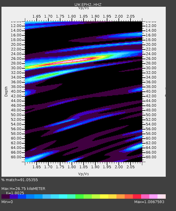
| Estimated Moho Depth: |
26.75 km |
| Estimated Crust Vp/Vs: |
1.80 |
| Assumed Crust Vp: |
6.419 km/s |
| Estimated Crust Vs: |
3.561 km/s |
| Estimated Crust Poisson's Ratio: |
0.28 |
|
| Radial Match: |
91.05355 % |
| Radial Bump: |
371 |
| Transverse Match: |
73.260414 % |
| Transverse Bump: |
400 |
| SOD ConfigId: |
28764291 |
| Insert Time: |
2022-10-30 13:28:15.655 +0000 |
| GWidth: |
2.5 |
| Max Bumps: |
400 |
| Tol: |
0.001 |
|

Signal To Noise
| Channel | StoN | STA | LTA |
| UW:EPH2: :HHZ:20221016T12:56:52.669986Z | 8.72208 | 2.0461625E-6 | 2.345957E-7 |
| UW:EPH2: :HHN:20221016T12:56:52.669986Z | 4.266246 | 8.465921E-7 | 1.984396E-7 |
| UW:EPH2: :HHE:20221016T12:56:52.669986Z | 3.179849 | 8.859507E-7 | 2.786141E-7 |
| Arrivals |
| Ps | 3.5 SECOND |
| PpPs | 11 SECOND |
| PsPs/PpSs | 15 SECOND |


