You are here: Home > Network List > UW - Pacific Northwest Regional Seismic Network Stations List
> Station ETW Entiat, WA, USA > Earthquake Result Viewer
ETW Entiat, WA, USA - Earthquake Result Viewer
| Earthquake location: |
Off Coast Of Central America |
| Earthquake latitude/longitude: |
4.4/-87.5 |
| Earthquake time(UTC): |
2022/10/16 (289) 12:48:21 GMT |
| Earthquake Depth: |
10 km |
| Earthquake Magnitude: |
6.3 Mww |
| Earthquake Catalog/Contributor: |
NEIC PDE/us |
|
| Network: |
UW Pacific Northwest Regional Seismic Network |
| Station: |
ETW Entiat, WA, USA |
| Lat/Lon: |
47.60 N/120.33 W |
| Elevation: |
1469 m |
|
| Distance: |
51.5 deg |
| Az: |
332.043 deg |
| Baz: |
136.308 deg |
| Ray Param: |
0.06739316 |
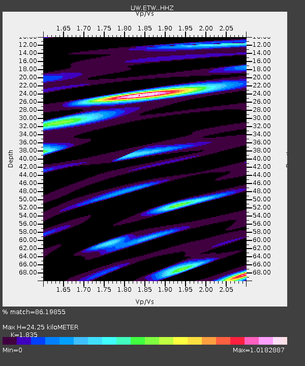
| Estimated Moho Depth: |
24.25 km |
| Estimated Crust Vp/Vs: |
1.84 |
| Assumed Crust Vp: |
6.597 km/s |
| Estimated Crust Vs: |
3.595 km/s |
| Estimated Crust Poisson's Ratio: |
0.29 |
|
| Radial Match: |
86.19855 % |
| Radial Bump: |
371 |
| Transverse Match: |
78.863976 % |
| Transverse Bump: |
400 |
| SOD ConfigId: |
28764291 |
| Insert Time: |
2022-10-30 13:30:53.804 +0000 |
| GWidth: |
2.5 |
| Max Bumps: |
400 |
| Tol: |
0.001 |
|

Signal To Noise
| Channel | StoN | STA | LTA |
| UW:ETW: :HHZ:20221016T12:56:56.459994Z | 8.173792 | 1.7496878E-6 | 2.1406073E-7 |
| UW:ETW: :HHN:20221016T12:56:56.459994Z | 6.8879747 | 7.420078E-7 | 1.077251E-7 |
| UW:ETW: :HHE:20221016T12:56:56.459994Z | 5.084337 | 9.2379645E-7 | 1.8169456E-7 |
| Arrivals |
| Ps | 3.3 SECOND |
| PpPs | 9.8 SECOND |
| PsPs/PpSs | 13 SECOND |


