You are here: Home > Network List > CN - Canadian National Seismograph Network Stations List
> Station INK INUVIK, NT > Earthquake Result Viewer
INK INUVIK, NT - Earthquake Result Viewer
*The percent match for this event was below the threshold and hence no stack was calculated.
| Earthquake location: |
Northwest Of Ryukyu Islands |
| Earthquake latitude/longitude: |
27.7/126.9 |
| Earthquake time(UTC): |
2022/10/06 (279) 16:36:10 GMT |
| Earthquake Depth: |
179 km |
| Earthquake Magnitude: |
5.3 mww |
| Earthquake Catalog/Contributor: |
NEIC PDE/us |
|
| Network: |
CN Canadian National Seismograph Network |
| Station: |
INK INUVIK, NT |
| Lat/Lon: |
68.31 N/133.53 W |
| Elevation: |
44 m |
|
| Distance: |
68.1 deg |
| Az: |
23.276 deg |
| Baz: |
289.475 deg |
| Ray Param: |
$rayparam |
*The percent match for this event was below the threshold and hence was not used in the summary stack. |
|
| Radial Match: |
54.319477 % |
| Radial Bump: |
400 |
| Transverse Match: |
61.56907 % |
| Transverse Bump: |
400 |
| SOD ConfigId: |
28764291 |
| Insert Time: |
2022-11-02 20:29:24.480 +0000 |
| GWidth: |
2.5 |
| Max Bumps: |
400 |
| Tol: |
0.001 |
|
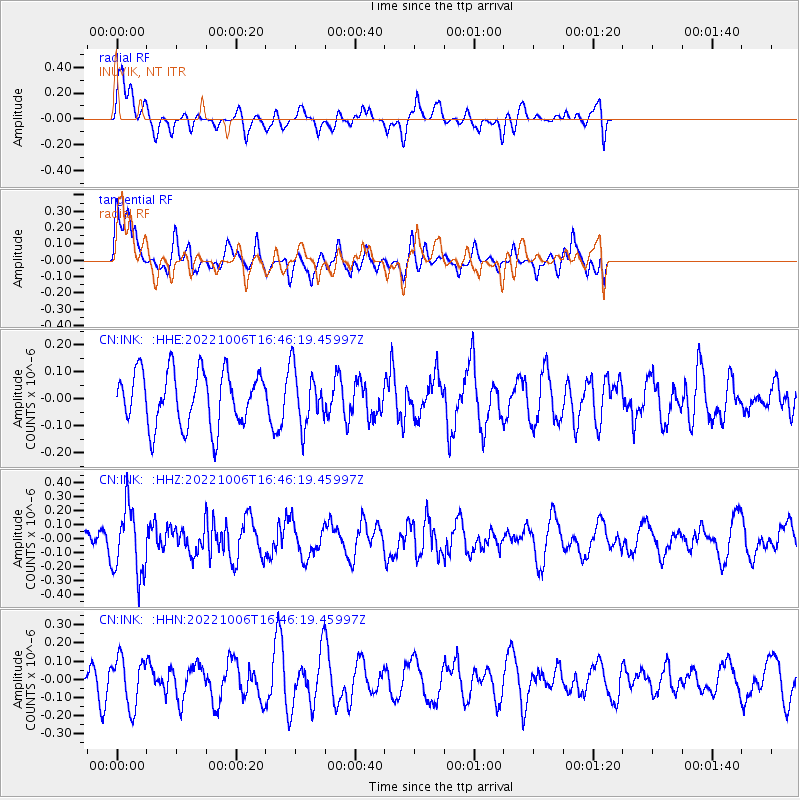
Signal To Noise
| Channel | StoN | STA | LTA |
| CN:INK: :HHZ:20221006T16:46:19.45997Z | 1.691659 | 2.4156793E-7 | 1.4279942E-7 |
| CN:INK: :HHN:20221006T16:46:19.45997Z | 2.4149654 | 1.3370568E-7 | 5.536546E-8 |
| CN:INK: :HHE:20221006T16:46:19.45997Z | 1.040942 | 1.04179385E-7 | 1.0008184E-7 |
| Arrivals |
| Ps | |
| PpPs | |
| PsPs/PpSs | |


