You are here: Home > Network List > IU - Global Seismograph Network (GSN - IRIS/USGS) Stations List
> Station PMG Port Moresby, New Guinea > Earthquake Result Viewer
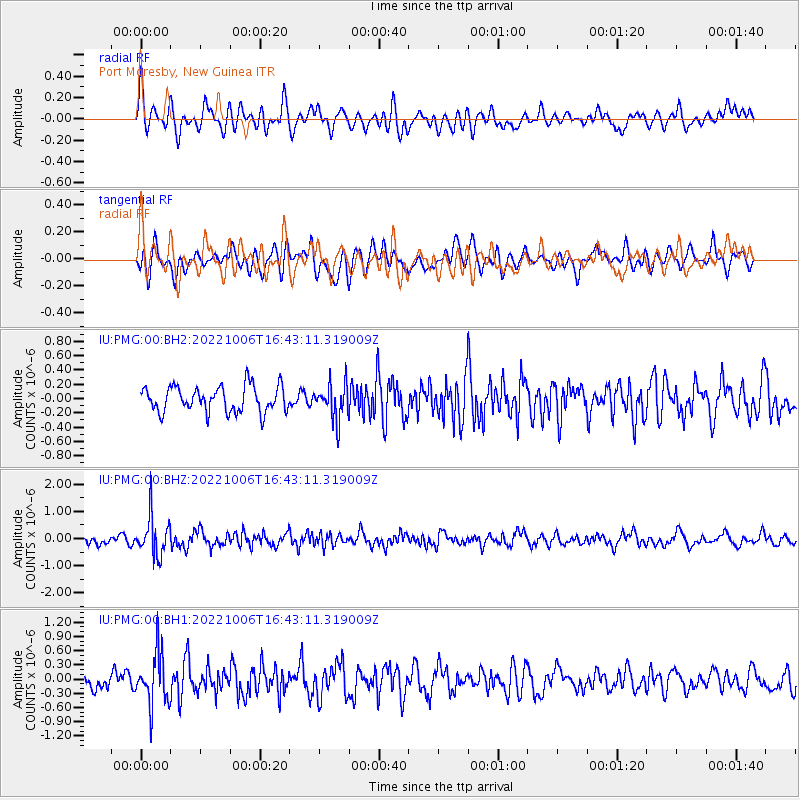
PMG Port Moresby, New Guinea - Earthquake Result Viewer
*The percent match for this event was below the threshold and hence no stack was calculated.
| Earthquake location: |
Northwest Of Ryukyu Islands |
| Earthquake latitude/longitude: |
27.7/126.9 |
| Earthquake time(UTC): |
2022/10/06 (279) 16:36:10 GMT |
| Earthquake Depth: |
179 km |
| Earthquake Magnitude: |
5.3 mww |
| Earthquake Catalog/Contributor: |
NEIC PDE/us |
|
| Network: |
IU Global Seismograph Network (GSN - IRIS/USGS) |
| Station: |
PMG Port Moresby, New Guinea |
| Lat/Lon: |
9.40 S/147.16 E |
| Elevation: |
90 m |
|
| Distance: |
41.8 deg |
| Az: |
149.065 deg |
| Baz: |
332.476 deg |
| Ray Param: |
$rayparam |
*The percent match for this event was below the threshold and hence was not used in the summary stack. |
|
| Radial Match: |
60.851295 % |
| Radial Bump: |
400 |
| Transverse Match: |
49.822994 % |
| Transverse Bump: |
400 |
| SOD ConfigId: |
28764291 |
| Insert Time: |
2022-11-02 20:32:34.225 +0000 |
| GWidth: |
2.5 |
| Max Bumps: |
400 |
| Tol: |
0.001 |
|
Signal To Noise
| Channel | StoN | STA | LTA |
| IU:PMG:00:BHZ:20221006T16:43:11.319009Z | 4.2554116 | 7.317717E-7 | 1.7196261E-7 |
| IU:PMG:00:BH1:20221006T16:43:11.319009Z | 3.0851305 | 5.4498804E-7 | 1.766499E-7 |
| IU:PMG:00:BH2:20221006T16:43:11.319009Z | 1.3497896 | 2.4391906E-7 | 1.8070894E-7 |
| Arrivals |
| Ps | |
| PpPs | |
| PsPs/PpSs | |


