You are here: Home > Network List > AK - Alaska Regional Network Stations List
> Station D17K Noatak River, AK, USA > Earthquake Result Viewer
D17K Noatak River, AK, USA - Earthquake Result Viewer
| Earthquake location: |
South Of Panama |
| Earthquake latitude/longitude: |
7.7/-82.3 |
| Earthquake time(UTC): |
2022/10/20 (293) 11:57:14 GMT |
| Earthquake Depth: |
10 km |
| Earthquake Magnitude: |
6.9 Mi |
| Earthquake Catalog/Contributor: |
NEIC PDE/at |
|
| Network: |
AK Alaska Regional Network |
| Station: |
D17K Noatak River, AK, USA |
| Lat/Lon: |
67.70 N/163.08 W |
| Elevation: |
172 m |
|
| Distance: |
79.4 deg |
| Az: |
337.465 deg |
| Baz: |
95.6 deg |
| Ray Param: |
0.048979077 |
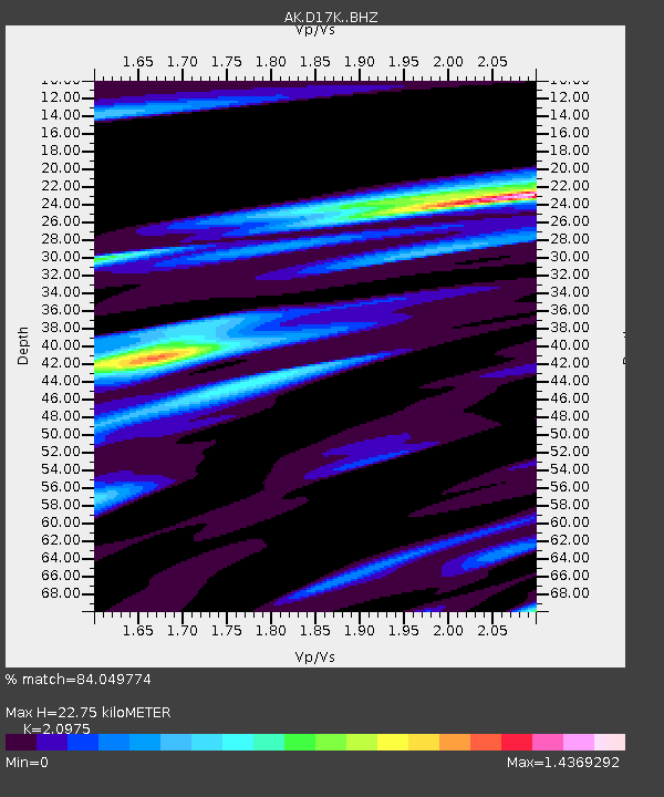
| Estimated Moho Depth: |
22.75 km |
| Estimated Crust Vp/Vs: |
2.10 |
| Assumed Crust Vp: |
6.276 km/s |
| Estimated Crust Vs: |
2.992 km/s |
| Estimated Crust Poisson's Ratio: |
0.35 |
|
| Radial Match: |
84.049774 % |
| Radial Bump: |
299 |
| Transverse Match: |
74.15384 % |
| Transverse Bump: |
400 |
| SOD ConfigId: |
28764291 |
| Insert Time: |
2022-11-03 12:02:33.963 +0000 |
| GWidth: |
2.5 |
| Max Bumps: |
400 |
| Tol: |
0.001 |
|

Signal To Noise
| Channel | StoN | STA | LTA |
| AK:D17K: :BHZ:20221020T12:08:48.880005Z | 10.217082 | 2.235311E-6 | 2.1878174E-7 |
| AK:D17K: :BHN:20221020T12:08:48.880005Z | 1.6275703 | 5.014208E-7 | 3.0807936E-7 |
| AK:D17K: :BHE:20221020T12:08:48.880005Z | 3.9337468 | 1.3483608E-6 | 3.4276758E-7 |
| Arrivals |
| Ps | 4.1 SECOND |
| PpPs | 11 SECOND |
| PsPs/PpSs | 15 SECOND |


