You are here: Home > Network List > AK - Alaska Regional Network Stations List
> Station GLB Gilahina Butte, AK, USA > Earthquake Result Viewer
GLB Gilahina Butte, AK, USA - Earthquake Result Viewer
| Earthquake location: |
South Of Panama |
| Earthquake latitude/longitude: |
7.7/-82.3 |
| Earthquake time(UTC): |
2022/10/20 (293) 11:57:14 GMT |
| Earthquake Depth: |
10 km |
| Earthquake Magnitude: |
6.9 Mi |
| Earthquake Catalog/Contributor: |
NEIC PDE/at |
|
| Network: |
AK Alaska Regional Network |
| Station: |
GLB Gilahina Butte, AK, USA |
| Lat/Lon: |
61.44 N/143.81 W |
| Elevation: |
855 m |
|
| Distance: |
69.9 deg |
| Az: |
333.27 deg |
| Baz: |
111.924 deg |
| Ray Param: |
0.05535668 |
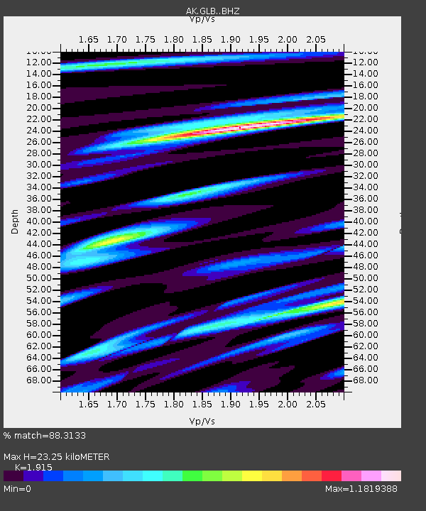
| Estimated Moho Depth: |
23.25 km |
| Estimated Crust Vp/Vs: |
1.91 |
| Assumed Crust Vp: |
6.566 km/s |
| Estimated Crust Vs: |
3.429 km/s |
| Estimated Crust Poisson's Ratio: |
0.31 |
|
| Radial Match: |
88.3133 % |
| Radial Bump: |
400 |
| Transverse Match: |
77.0172 % |
| Transverse Bump: |
400 |
| SOD ConfigId: |
28764291 |
| Insert Time: |
2022-11-03 12:03:13.083 +0000 |
| GWidth: |
2.5 |
| Max Bumps: |
400 |
| Tol: |
0.001 |
|

Signal To Noise
| Channel | StoN | STA | LTA |
| AK:GLB: :BHZ:20221020T12:07:53.747986Z | 8.361817 | 2.877475E-6 | 3.441208E-7 |
| AK:GLB: :BHN:20221020T12:07:53.747986Z | 2.4472854 | 7.309752E-7 | 2.9868818E-7 |
| AK:GLB: :BHE:20221020T12:07:53.747986Z | 6.573638 | 1.2205636E-6 | 1.856755E-7 |
| Arrivals |
| Ps | 3.4 SECOND |
| PpPs | 10.0 SECOND |
| PsPs/PpSs | 13 SECOND |


