MM07 Sigel, Pennsylvania - Earthquake Result Viewer
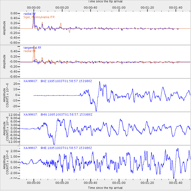
Earthquake location: Peru-Ecuador Border Region
Earthquake latitude/longitude: -2.8/-77.9
Earthquake time(UTC): 1995/10/03 (276) 01:51:24 GMT
Earthquake Depth: 27 km
Earthquake Magnitude: 6.5 MB, 7.0 MS, 6.9 UNKNOWN, 7.0 MW
Earthquake Catalog/Contributor: WHDF/NEIC
Network: XA Missouri to Massachusetts Transect
Station: MM07 Sigel, Pennsylvania
Lat/Lon: 41.26 N/79.14 W
Elevation: 518 m
Distance: 43.8 deg
Az: 358.638 deg
Baz: 178.196 deg
Ray Param: 0.07224343
Estimated Moho Depth: 13.0 km
Estimated Crust Vp/Vs: 2.01
Assumed Crust Vp: 6.121 km/s
Estimated Crust Vs: 3.053 km/s
Estimated Crust Poisson's Ratio: 0.33
Radial Match: 97.79534 %
Radial Bump: 352
Transverse Match: 86.80019 %
Transverse Bump: 400
SOD ConfigId: 6273
Insert Time: 2010-02-26 17:47:35.519 +0000
GWidth: 2.5
Max Bumps: 400
Tol: 0.001

Signal To Noise

ChannelStoNSTALTA
XA:MM07: :BHN:19951003T01:58:57.153986Z2.056614.879261E-72.3724776E-7
XA:MM07: :BHE:19951003T01:58:57.153986Z1.18440252.7083914E-72.2867155E-7
XA:MM07: :BHZ:19951003T01:58:57.153986Z5.31048441.1178377E-62.1049637E-7
Arrivals
Ps2.2 SECOND
PpPs6.1 SECOND
PsPs/PpSs8.3 SECOND