You are here: Home > Network List > US - United States National Seismic Network Stations List
> Station MSO Missoula, Montana, USA > Earthquake Result Viewer
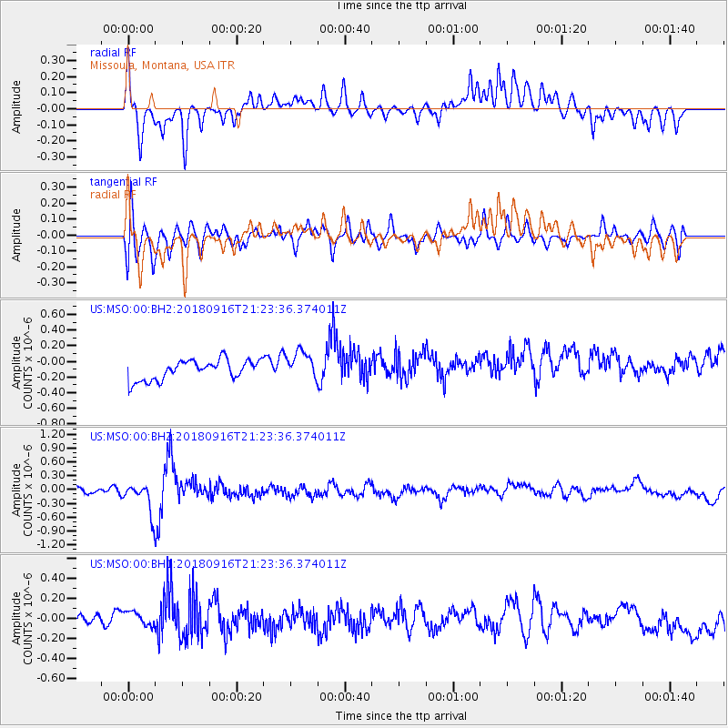
MSO Missoula, Montana, USA - Earthquake Result Viewer
*The percent match for this event was below the threshold and hence no stack was calculated.
| Earthquake location: |
South Of Fiji Islands |
| Earthquake latitude/longitude: |
-25.5/178.2 |
| Earthquake time(UTC): |
2018/09/16 (259) 21:11:48 GMT |
| Earthquake Depth: |
570 km |
| Earthquake Magnitude: |
6.5 Mww |
| Earthquake Catalog/Contributor: |
NEIC PDE/us |
|
| Network: |
US United States National Seismic Network |
| Station: |
MSO Missoula, Montana, USA |
| Lat/Lon: |
46.83 N/113.94 W |
| Elevation: |
1264 m |
|
| Distance: |
94.4 deg |
| Az: |
39.626 deg |
| Baz: |
237.113 deg |
| Ray Param: |
$rayparam |
*The percent match for this event was below the threshold and hence was not used in the summary stack. |
|
| Radial Match: |
63.32758 % |
| Radial Bump: |
386 |
| Transverse Match: |
65.74924 % |
| Transverse Bump: |
400 |
| SOD ConfigId: |
2825771 |
| Insert Time: |
2018-09-30 21:25:56.490 +0000 |
| GWidth: |
2.5 |
| Max Bumps: |
400 |
| Tol: |
0.001 |
|
Signal To Noise
| Channel | StoN | STA | LTA |
| US:MSO:00:BHZ:20180916T21:23:36.374011Z | 4.2999163 | 3.1118944E-7 | 7.2371044E-8 |
| US:MSO:00:BH1:20180916T21:23:36.374011Z | 0.9836202 | 1.0724162E-7 | 1.0902747E-7 |
| US:MSO:00:BH2:20180916T21:23:36.374011Z | 1.4493873 | 1.8189495E-7 | 1.2549782E-7 |
| Arrivals |
| Ps | |
| PpPs | |
| PsPs/PpSs | |


