You are here: Home > Network List > AV - Alaska Volcano Observatory Stations List
> Station MAPS Pakushin Southeast, Makushin Volcano, Alaska > Earthquake Result Viewer
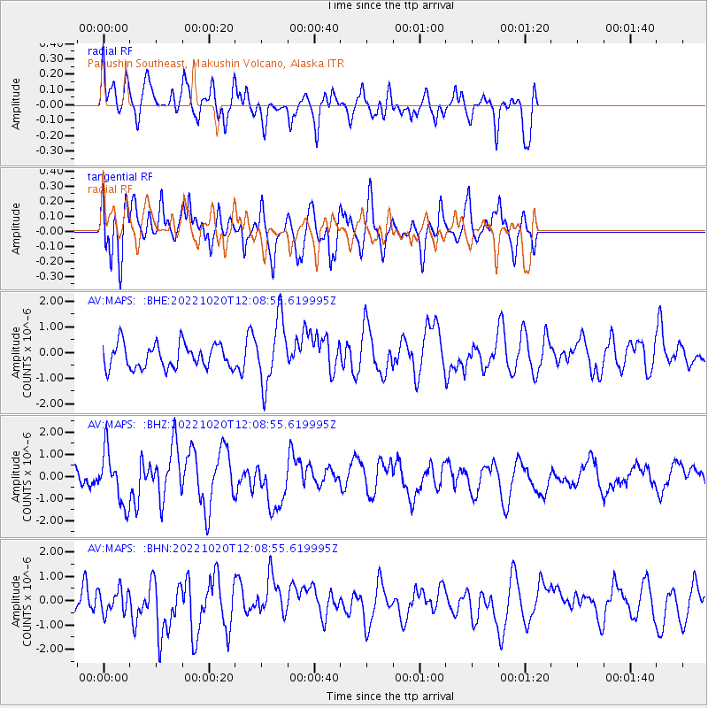
MAPS Pakushin Southeast, Makushin Volcano, Alaska - Earthquake Result Viewer
*The percent match for this event was below the threshold and hence no stack was calculated.
| Earthquake location: |
South Of Panama |
| Earthquake latitude/longitude: |
7.7/-82.3 |
| Earthquake time(UTC): |
2022/10/20 (293) 11:57:14 GMT |
| Earthquake Depth: |
10 km |
| Earthquake Magnitude: |
6.9 Mi |
| Earthquake Catalog/Contributor: |
NEIC PDE/at |
|
| Network: |
AV Alaska Volcano Observatory |
| Station: |
MAPS Pakushin Southeast, Makushin Volcano, Alaska |
| Lat/Lon: |
53.81 N/166.94 W |
| Elevation: |
333 m |
|
| Distance: |
80.7 deg |
| Az: |
323.245 deg |
| Baz: |
89.744 deg |
| Ray Param: |
$rayparam |
*The percent match for this event was below the threshold and hence was not used in the summary stack. |
|
| Radial Match: |
68.062225 % |
| Radial Bump: |
400 |
| Transverse Match: |
68.21123 % |
| Transverse Bump: |
400 |
| SOD ConfigId: |
28764291 |
| Insert Time: |
2022-11-03 12:06:50.473 +0000 |
| GWidth: |
2.5 |
| Max Bumps: |
400 |
| Tol: |
0.001 |
|
Signal To Noise
| Channel | StoN | STA | LTA |
| AV:MAPS: :BHZ:20221020T12:08:55.619995Z | 1.6494545 | 1.1884686E-6 | 7.2052217E-7 |
| AV:MAPS: :BHN:20221020T12:08:55.619995Z | 0.45117772 | 4.847695E-7 | 1.0744534E-6 |
| AV:MAPS: :BHE:20221020T12:08:55.619995Z | 2.7336204 | 1.2786332E-6 | 4.6774352E-7 |
| Arrivals |
| Ps | |
| PpPs | |
| PsPs/PpSs | |


