You are here: Home > Network List > AZ - ANZA Regional Network Stations List
> Station FRD AZ.FRD > Earthquake Result Viewer
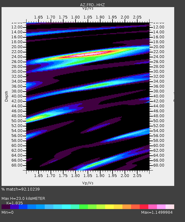
FRD AZ.FRD - Earthquake Result Viewer
| Earthquake location: |
South Of Panama |
| Earthquake latitude/longitude: |
7.7/-82.3 |
| Earthquake time(UTC): |
2022/10/20 (293) 11:57:14 GMT |
| Earthquake Depth: |
10 km |
| Earthquake Magnitude: |
6.9 Mi |
| Earthquake Catalog/Contributor: |
NEIC PDE/at |
|
| Network: |
AZ ANZA Regional Network |
| Station: |
FRD AZ.FRD |
| Lat/Lon: |
33.49 N/116.60 W |
| Elevation: |
1164 m |
|
| Distance: |
40.8 deg |
| Az: |
313.857 deg |
| Baz: |
121.216 deg |
| Ray Param: |
0.07420261 |
| Estimated Moho Depth: |
23.0 km |
| Estimated Crust Vp/Vs: |
1.84 |
| Assumed Crust Vp: |
6.264 km/s |
| Estimated Crust Vs: |
3.413 km/s |
| Estimated Crust Poisson's Ratio: |
0.29 |
|
| Radial Match: |
92.10239 % |
| Radial Bump: |
400 |
| Transverse Match: |
76.19723 % |
| Transverse Bump: |
400 |
| SOD ConfigId: |
28764291 |
| Insert Time: |
2022-11-03 12:07:55.688 +0000 |
| GWidth: |
2.5 |
| Max Bumps: |
400 |
| Tol: |
0.001 |
|

Signal To Noise
| Channel | StoN | STA | LTA |
| AZ:FRD: :HHZ:20221020T12:04:24.368011Z | 12.210323 | 3.1341146E-6 | 2.5667745E-7 |
| AZ:FRD: :HHN:20221020T12:04:24.368011Z | 3.037816 | 9.676025E-7 | 3.1851914E-7 |
| AZ:FRD: :HHE:20221020T12:04:24.368011Z | 10.868216 | 2.1225126E-6 | 1.952954E-7 |
| Arrivals |
| Ps | 3.3 SECOND |
| PpPs | 9.8 SECOND |
| PsPs/PpSs | 13 SECOND |


