You are here: Home > Network List > XA95 - Missouri to Massachusetts Transect Stations List
> Station MM07 Sigel, Pennsylvania > Earthquake Result Viewer
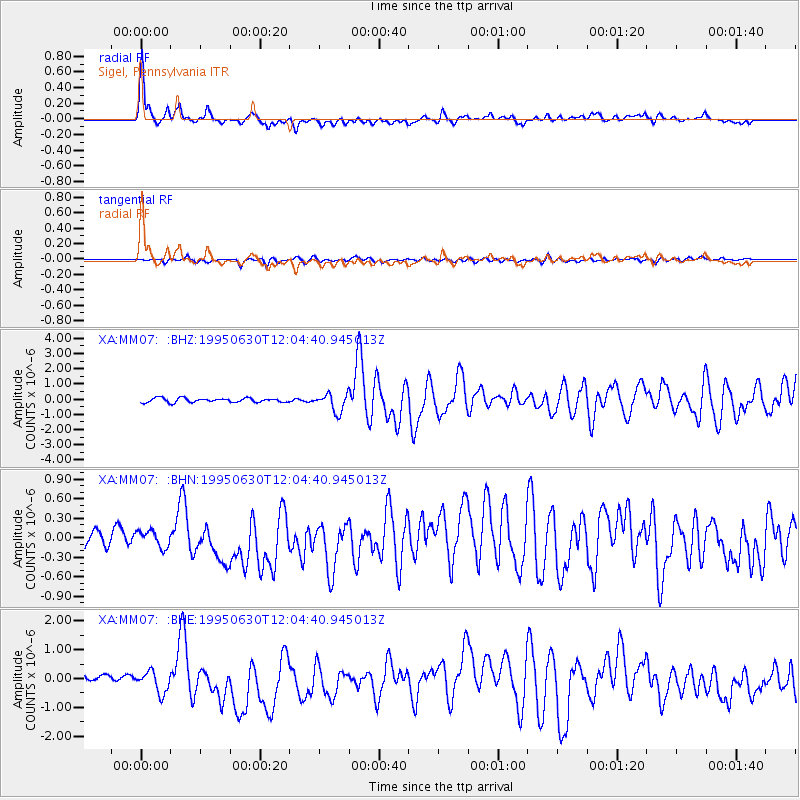
MM07 Sigel, Pennsylvania - Earthquake Result Viewer

| Earthquake location: |
Baja California, Mexico |
| Earthquake latitude/longitude: |
24.6/-110.3 |
| Earthquake time(UTC): |
1995/06/30 (181) 11:58:56 GMT |
| Earthquake Depth: |
10 km |
| Earthquake Magnitude: |
5.8 MB, 6.3 MS, 6.2 UNKNOWN |
| Earthquake Catalog/Contributor: |
WHDF/NEIC |
|
| Network: |
XA Missouri to Massachusetts Transect |
| Station: |
MM07 Sigel, Pennsylvania |
| Lat/Lon: |
41.26 N/79.14 W |
| Elevation: |
518 m |
|
| Distance: |
30.7 deg |
| Az: |
49.703 deg |
| Baz: |
247.029 deg |
| Ray Param: |
0.07925461 |
| Estimated Moho Depth: |
45.0 km |
| Estimated Crust Vp/Vs: |
1.85 |
| Assumed Crust Vp: |
6.121 km/s |
| Estimated Crust Vs: |
3.317 km/s |
| Estimated Crust Poisson's Ratio: |
0.29 |
|
| Radial Match: |
82.8903 % |
| Radial Bump: |
400 |
| Transverse Match: |
60.117348 % |
| Transverse Bump: |
400 |
| SOD ConfigId: |
6273 |
| Insert Time: |
2010-02-26 17:47:42.567 +0000 |
| GWidth: |
2.5 |
| Max Bumps: |
400 |
| Tol: |
0.001 |
|
Signal To Noise
| Channel | StoN | STA | LTA |
| XA:MM07: :BHN:19950630T12:04:40.945013Z | 1.2635041 | 1.7665307E-7 | 1.3981203E-7 |
| XA:MM07: :BHE:19950630T12:04:40.945013Z | 3.5369768 | 4.851146E-7 | 1.3715514E-7 |
| XA:MM07: :BHZ:19950630T12:04:40.945013Z | 4.3031445 | 6.027623E-7 | 1.4007486E-7 |
| Arrivals |
| Ps | 6.7 SECOND |
| PpPs | 20 SECOND |
| PsPs/PpSs | 26 SECOND |


