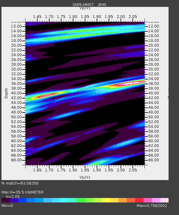
MM07 Sigel, Pennsylvania - Earthquake Result Viewer

Earthquake location: Rat Islands, Aleutian Islands
Earthquake latitude/longitude: 51.3/179.7
Earthquake time(UTC): 1995/04/23 (113) 02:55:54 GMT
Earthquake Depth: 16 km
Earthquake Magnitude: 6.1 MB, 6.4 MS, 6.5 UNKNOWN, 6.7 ML
Earthquake Catalog/Contributor: WHDF/NEIC
Network: XA Missouri to Massachusetts Transect
Station: MM07 Sigel, Pennsylvania
Lat/Lon: 41.26 N/79.14 W
Elevation: 518 m
Distance: 65.2 deg
Az: 54.603 deg
Baz: 317.299 deg
Ray Param: 0.058444753
Estimated Moho Depth: 35.5 km
Estimated Crust Vp/Vs: 2.05
Assumed Crust Vp: 6.121 km/s
Estimated Crust Vs: 2.986 km/s
Estimated Crust Poisson's Ratio: 0.34
Radial Match: 93.06358 %
Radial Bump: 400
Transverse Match: 79.96389 %
Transverse Bump: 400
SOD ConfigId: 6273
Insert Time: 2010-02-26 17:47:49.619 +0000
GWidth: 2.5
Max Bumps: 400
Tol: 0.001

Signal To Noise

ChannelStoNSTALTA
XA:MM07: :BHN:19950423T03:06:03.855017Z4.8960495.112688E-71.0442478E-7
XA:MM07: :BHE:19950423T03:06:03.855017Z3.7731965.6791265E-71.5051236E-7
XA:MM07: :BHZ:19950423T03:06:03.855017Z10.8202841.7870843E-61.6516057E-7
Arrivals
Ps6.3 SECOND
PpPs17 SECOND
PsPs/PpSs23 SECOND