You are here: Home > Network List > GM - US Geological Survey Networks Stations List
> Station NMP01 New Mexico Permian - Site# 01 > Earthquake Result Viewer
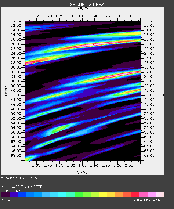
NMP01 New Mexico Permian - Site# 01 - Earthquake Result Viewer
| Earthquake location: |
South Of Panama |
| Earthquake latitude/longitude: |
7.7/-82.3 |
| Earthquake time(UTC): |
2022/10/20 (293) 11:57:14 GMT |
| Earthquake Depth: |
10 km |
| Earthquake Magnitude: |
6.9 Mi |
| Earthquake Catalog/Contributor: |
NEIC PDE/at |
|
| Network: |
GM US Geological Survey Networks |
| Station: |
NMP01 New Mexico Permian - Site# 01 |
| Lat/Lon: |
32.20 N/103.86 W |
| Elevation: |
1048 m |
|
| Distance: |
31.6 deg |
| Az: |
323.481 deg |
| Baz: |
135.916 deg |
| Ray Param: |
0.079026826 |
| Estimated Moho Depth: |
20.0 km |
| Estimated Crust Vp/Vs: |
1.89 |
| Assumed Crust Vp: |
6.129 km/s |
| Estimated Crust Vs: |
3.234 km/s |
| Estimated Crust Poisson's Ratio: |
0.31 |
|
| Radial Match: |
87.33489 % |
| Radial Bump: |
400 |
| Transverse Match: |
73.23414 % |
| Transverse Bump: |
400 |
| SOD ConfigId: |
28764291 |
| Insert Time: |
2022-11-03 12:19:24.954 +0000 |
| GWidth: |
2.5 |
| Max Bumps: |
400 |
| Tol: |
0.001 |
|

Signal To Noise
| Channel | StoN | STA | LTA |
| GM:NMP01:01:HHZ:20221020T12:03:05.850006Z | 15.457293 | 2.6801436E-6 | 1.7339023E-7 |
| GM:NMP01:01:HHN:20221020T12:03:05.850006Z | 3.7231998 | 7.012413E-7 | 1.883437E-7 |
| GM:NMP01:01:HHE:20221020T12:03:05.850006Z | 5.5767274 | 1.3435216E-6 | 2.409158E-7 |
| Arrivals |
| Ps | 3.1 SECOND |
| PpPs | 8.8 SECOND |
| PsPs/PpSs | 12 SECOND |


