You are here: Home > Network List > GM - US Geological Survey Networks Stations List
> Station NMP45 New Mexico Permian - Site# W4S5 > Earthquake Result Viewer
NMP45 New Mexico Permian - Site# W4S5 - Earthquake Result Viewer
| Earthquake location: |
South Of Panama |
| Earthquake latitude/longitude: |
7.7/-82.3 |
| Earthquake time(UTC): |
2022/10/20 (293) 11:57:14 GMT |
| Earthquake Depth: |
10 km |
| Earthquake Magnitude: |
6.9 Mi |
| Earthquake Catalog/Contributor: |
NEIC PDE/at |
|
| Network: |
GM US Geological Survey Networks |
| Station: |
NMP45 New Mexico Permian - Site# W4S5 |
| Lat/Lon: |
32.33 N/103.58 W |
| Elevation: |
1127 m |
|
| Distance: |
31.5 deg |
| Az: |
323.973 deg |
| Baz: |
136.484 deg |
| Ray Param: |
0.07905352 |
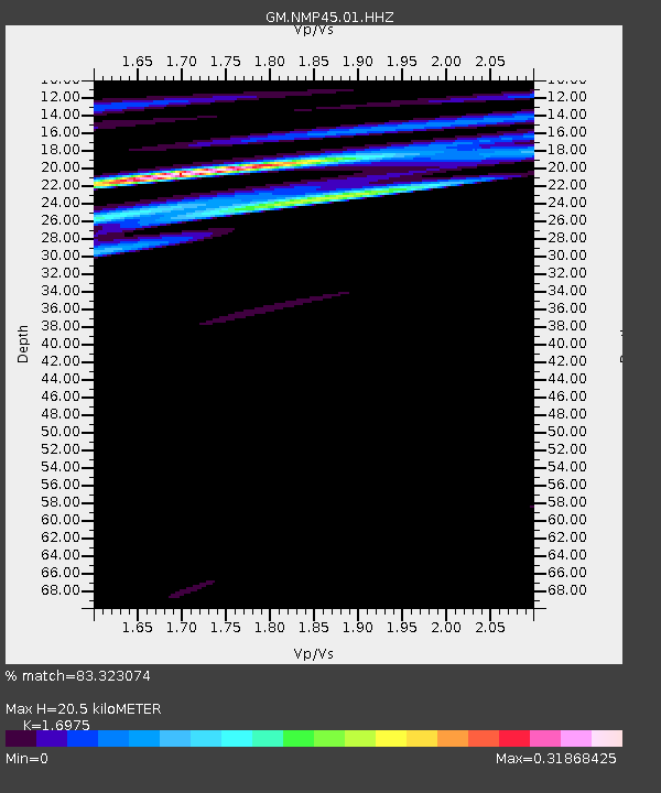
| Estimated Moho Depth: |
20.5 km |
| Estimated Crust Vp/Vs: |
1.70 |
| Assumed Crust Vp: |
6.129 km/s |
| Estimated Crust Vs: |
3.611 km/s |
| Estimated Crust Poisson's Ratio: |
0.23 |
|
| Radial Match: |
83.323074 % |
| Radial Bump: |
400 |
| Transverse Match: |
65.18916 % |
| Transverse Bump: |
400 |
| SOD ConfigId: |
28764291 |
| Insert Time: |
2022-11-03 12:19:39.454 +0000 |
| GWidth: |
2.5 |
| Max Bumps: |
400 |
| Tol: |
0.001 |
|

Signal To Noise
| Channel | StoN | STA | LTA |
| GM:NMP45:01:HHZ:20221020T12:03:05.214996Z | 12.676681 | 2.3554287E-6 | 1.85808E-7 |
| GM:NMP45:01:HHN:20221020T12:03:05.214996Z | 1.830341 | 7.5220197E-7 | 4.1096274E-7 |
| GM:NMP45:01:HHE:20221020T12:03:05.214996Z | 2.191417 | 1.2030409E-6 | 5.4897856E-7 |
| Arrivals |
| Ps | 2.5 SECOND |
| PpPs | 8.4 SECOND |
| PsPs/PpSs | 11 SECOND |


