You are here: Home > Network List > N4 - Central and EAstern US Network Stations List
> Station M44A Midewin, Midewin Nat. Tallgrass Prarie, IL, USA > Earthquake Result Viewer
M44A Midewin, Midewin Nat. Tallgrass Prarie, IL, USA - Earthquake Result Viewer
| Earthquake location: |
South Of Panama |
| Earthquake latitude/longitude: |
7.7/-82.3 |
| Earthquake time(UTC): |
2022/10/20 (293) 11:57:14 GMT |
| Earthquake Depth: |
10 km |
| Earthquake Magnitude: |
6.9 Mi |
| Earthquake Catalog/Contributor: |
NEIC PDE/at |
|
| Network: |
N4 Central and EAstern US Network |
| Station: |
M44A Midewin, Midewin Nat. Tallgrass Prarie, IL, USA |
| Lat/Lon: |
41.39 N/88.04 W |
| Elevation: |
207 m |
|
| Distance: |
33.9 deg |
| Az: |
352.248 deg |
| Baz: |
169.766 deg |
| Ray Param: |
0.07799237 |
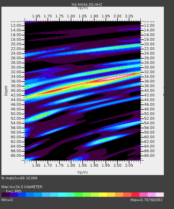
| Estimated Moho Depth: |
34.0 km |
| Estimated Crust Vp/Vs: |
2.00 |
| Assumed Crust Vp: |
6.498 km/s |
| Estimated Crust Vs: |
3.257 km/s |
| Estimated Crust Poisson's Ratio: |
0.33 |
|
| Radial Match: |
89.30399 % |
| Radial Bump: |
332 |
| Transverse Match: |
65.496735 % |
| Transverse Bump: |
400 |
| SOD ConfigId: |
28764291 |
| Insert Time: |
2022-11-03 12:23:18.991 +0000 |
| GWidth: |
2.5 |
| Max Bumps: |
400 |
| Tol: |
0.001 |
|

Signal To Noise
| Channel | StoN | STA | LTA |
| N4:M44A:00:HHZ:20221020T12:03:26.489014Z | 11.932096 | 2.399347E-6 | 2.0108345E-7 |
| N4:M44A:00:HH1:20221020T12:03:26.489014Z | 5.2484393 | 8.231943E-7 | 1.5684554E-7 |
| N4:M44A:00:HH2:20221020T12:03:26.489014Z | 1.3899453 | 2.582135E-7 | 1.8577241E-7 |
| Arrivals |
| Ps | 5.6 SECOND |
| PpPs | 15 SECOND |
| PsPs/PpSs | 20 SECOND |


