You are here: Home > Network List > N4 - Central and EAstern US Network Stations List
> Station P48A Milroy, IN, USA > Earthquake Result Viewer
P48A Milroy, IN, USA - Earthquake Result Viewer
| Earthquake location: |
South Of Panama |
| Earthquake latitude/longitude: |
7.7/-82.3 |
| Earthquake time(UTC): |
2022/10/20 (293) 11:57:14 GMT |
| Earthquake Depth: |
10 km |
| Earthquake Magnitude: |
6.9 Mi |
| Earthquake Catalog/Contributor: |
NEIC PDE/at |
|
| Network: |
N4 Central and EAstern US Network |
| Station: |
P48A Milroy, IN, USA |
| Lat/Lon: |
39.46 N/85.43 W |
| Elevation: |
300 m |
|
| Distance: |
31.7 deg |
| Az: |
355.398 deg |
| Baz: |
174.105 deg |
| Ray Param: |
0.078956805 |
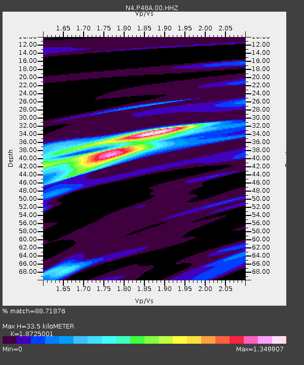
| Estimated Moho Depth: |
33.5 km |
| Estimated Crust Vp/Vs: |
1.87 |
| Assumed Crust Vp: |
6.498 km/s |
| Estimated Crust Vs: |
3.47 km/s |
| Estimated Crust Poisson's Ratio: |
0.30 |
|
| Radial Match: |
88.71876 % |
| Radial Bump: |
270 |
| Transverse Match: |
61.56221 % |
| Transverse Bump: |
400 |
| SOD ConfigId: |
28764291 |
| Insert Time: |
2022-11-03 12:23:45.511 +0000 |
| GWidth: |
2.5 |
| Max Bumps: |
400 |
| Tol: |
0.001 |
|

Signal To Noise
| Channel | StoN | STA | LTA |
| N4:P48A:00:HHZ:20221020T12:03:07.420013Z | 17.29565 | 3.190966E-6 | 1.8449528E-7 |
| N4:P48A:00:HH1:20221020T12:03:07.420013Z | 8.684101 | 1.7673111E-6 | 2.0351114E-7 |
| N4:P48A:00:HH2:20221020T12:03:07.420013Z | 2.116464 | 6.3114584E-7 | 2.982077E-7 |
| Arrivals |
| Ps | 4.9 SECOND |
| PpPs | 14 SECOND |
| PsPs/PpSs | 19 SECOND |


