You are here: Home > Network List > XA95 - Missouri to Massachusetts Transect Stations List
> Station MM07 Sigel, Pennsylvania > Earthquake Result Viewer
MM07 Sigel, Pennsylvania - Earthquake Result Viewer
| Earthquake location: |
Northern Peru |
| Earthquake latitude/longitude: |
-3.9/-77.0 |
| Earthquake time(UTC): |
1995/05/02 (122) 06:06:05 GMT |
| Earthquake Depth: |
103 km |
| Earthquake Magnitude: |
6.5 MB, 6.7 UNKNOWN, 6.6 MW |
| Earthquake Catalog/Contributor: |
WHDF/NEIC |
|
| Network: |
XA Missouri to Massachusetts Transect |
| Station: |
MM07 Sigel, Pennsylvania |
| Lat/Lon: |
41.26 N/79.14 W |
| Elevation: |
518 m |
|
| Distance: |
44.9 deg |
| Az: |
357.676 deg |
| Baz: |
176.924 deg |
| Ray Param: |
0.07124352 |
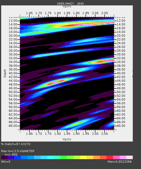
| Estimated Moho Depth: |
13.5 km |
| Estimated Crust Vp/Vs: |
1.99 |
| Assumed Crust Vp: |
6.121 km/s |
| Estimated Crust Vs: |
3.083 km/s |
| Estimated Crust Poisson's Ratio: |
0.33 |
|
| Radial Match: |
97.43278 % |
| Radial Bump: |
400 |
| Transverse Match: |
83.910774 % |
| Transverse Bump: |
400 |
| SOD ConfigId: |
6273 |
| Insert Time: |
2010-02-26 17:47:57.932 +0000 |
| GWidth: |
2.5 |
| Max Bumps: |
400 |
| Tol: |
0.001 |
|

Signal To Noise
| Channel | StoN | STA | LTA |
| XA:MM07: :BHN:19950502T06:13:40.11701Z | 21.668716 | 5.031348E-6 | 2.3219408E-7 |
| XA:MM07: :BHE:19950502T06:13:40.11701Z | 1.9818612 | 3.8615488E-7 | 1.9484456E-7 |
| XA:MM07: :BHZ:19950502T06:13:40.11701Z | 33.26933 | 1.29461805E-5 | 3.8913262E-7 |
| Arrivals |
| Ps | 2.3 SECOND |
| PpPs | 6.3 SECOND |
| PsPs/PpSs | 8.5 SECOND |


